You arrive in late November with a booking confirmation and a mental image of glassy green water. What you find instead is a 15-foot wall of white water detonating across the center of the bay, a yellow warning flag snapping in the wind, and a beach full of people watching instead of swimming. Hanalei Bay is more dramatic than the photos suggested. It’s just not what you booked.
The bay runs on a two-season system that splits it into two completely different beaches. Most booking platforms never explain which version you’re arriving for. The calendar does not come with a footnote.
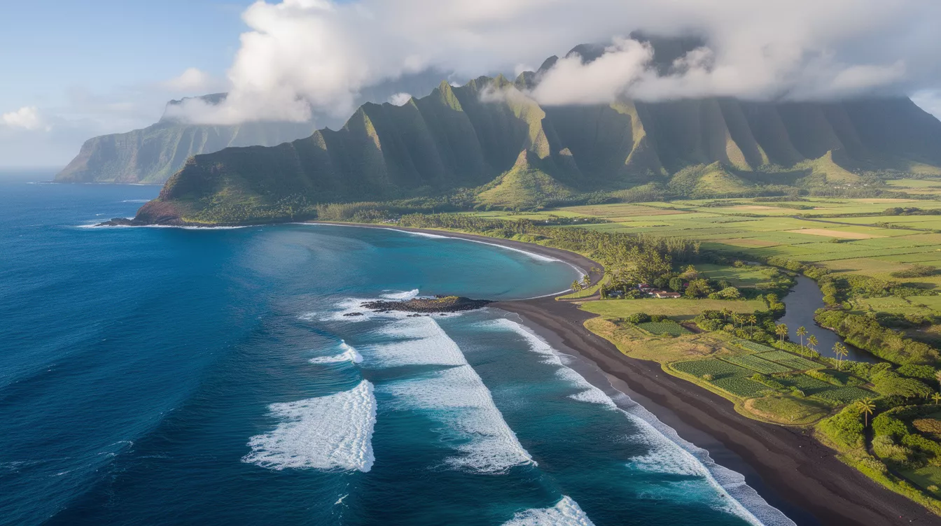
The bay faces northwest, and that one fact controls everything
Hanalei Bay is a roughly 2-mile arc on Kauai’s north shore, about 4 miles west of Princeville by road. That northwestern exposure opens it directly into the North Pacific swell window. From November through March, low-pressure systems tracking across the North Pacific generate swells that travel thousands of miles before standing up on the bay’s outer reef.
There’s no landmass between Hanalei and the Aleutian Islands to absorb those swells. Because the Na Pali cliffs to the west aren’t angled to block a northwest approach, the bay receives them without reduction. And that’s the structural fact that every summer Instagram post quietly leaves out.
The rain doesn’t help either, but it’s not the problem visitors expect. Hawaiian beach conditions are almost always geographic before they’re meteorological, and Hanalei is no different. The showers pass in minutes. What stays is the color: the taro fields of the Hanalei Valley Wildlife Refuge below peaks that push above 3,000 feet, soaked green by rainfall that can exceed 70 inches annually in the valley behind town.
Summer runs the family beach. Winter runs the surf season.
From roughly May through September, the North Pacific swell machine quiets. The bay’s center flattens. Water temperature sits around 78-80°F and the main beach fronting Hanalei town becomes swimmable for most adults. Stand-up paddleboard rentals operate from the river mouth, where the Hanalei River empties into the bay’s eastern end. That corner runs murky after rain. The western end, near Black Pot Beach Park, tends to run cleaner and clearer.
But parking along Weke Road fills by 9am on summer weekends. And that trade-off, easy water against a genuinely difficult arrival, is the one most people underestimate. The window between “quiet beach” and “full parking lot” closes fast at famous spots.
November through March, the outer break at the bay, called Hanalei Bay or “the Bowl” by local surfers, sees waves regularly reaching 15-25 feet on peak swell events. The bay’s center gets flagged or closed to swimmers on the heaviest days. This is when surf photographers arrive before dawn, and when the smell of salt spray carries all the way to the road.
The one-lane bridges keep the buses out
Route 560 west of Princeville crosses seven one-lane bridges before reaching Hanalei town. Most date to the early 20th century and they’re not being widened. Because no vehicle longer than roughly 40 feet clears the bridges cleanly, tour buses can’t reach the bay. That single infrastructure fact is why Hanalei doesn’t look like Waikiki. Access constraints, not regulations, are often what preserve a beach’s character.
A local outfitter who’s been running SUP rentals from the river mouth for years puts it simply: the bridges are the best thing that ever happened to the north shore. Kayak and SUP rentals run roughly $25-50 per session. A plate lunch from one of Hanalei town’s food trucks costs $12-16.
Your questions about Hanalei Bay answered
How do you get there from Lihue Airport?
Lihue Airport (LIH) sits about 30 miles and 45-60 minutes from Hanalei under normal conditions, longer on summer weekend mornings when the bridge backups stack up. Car rental is the only practical option. The Kauai Bus does operate a north shore route, but service doesn’t extend fully to Hanalei Bay on a reliable schedule for visitors. The logistics gap between an airport and a famous beach is almost always bigger than the booking page implies.
Which months give you the best odds of calm water?
June, July, and August are the most reliable months for flat water at the bay’s center. April and May are transitional, generally calm but variable. October carries residual North Pacific activity and can surprise visitors who assume summer rules still apply.
What does a day at Hanalei Bay actually cost?
Parking at Black Pot Beach Park is free but limited, and it fills early. Chair and umbrella rentals near the beach run approximately $20-35 per day when available. There’s no entry fee to the beach. Budget $60-100 for a full day including gear, food, and a rental activity.
The bay at 7am in July
The taro fields behind town are still in shadow. The peaks above carry their usual cloud. The water at the bay’s center is flat and green near the river mouth, darker blue farther out. A single outrigger crosses left to right, and nobody else is in the water yet.
That’s the version in the photos. It exists. It just only exists for about five months of the year, and the bay has never once adjusted its schedule to match anyone’s booking dates.