Kauaʻi sits 73 miles northwest of Oʻahu. The island covers 562 square miles, making it the fourth-largest in the Hawaiian chain. But size is not the point here. The point is what five million years of rain can do to volcanic rock.
Mount Waiʻaleʻale averages 460 inches of rain per year
That is 38 feet of water falling on a single peak. The measurement comes from a rain gauge at 5,075 feet elevation on the mountain’s east flank, recorded between 1931 and 1960. More recent data, 1949 to 2004, still shows 374 inches annually. Either figure makes this one of the wettest documented places on Earth.
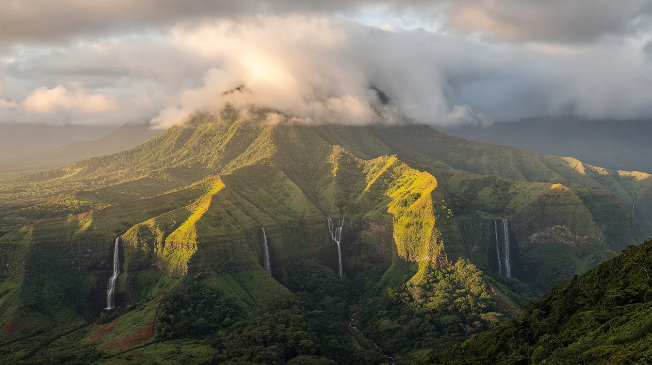
The rain has carved the interior into deep valleys. Waimea Canyon drops 3,000 feet below the west-side ridgeline. The Nā Pali Coast’s cliffs rise straight from the Pacific. You cannot drive through this terrain. You hike, boat, or fly over it.
In January 1956, a storm at the former Kīlauea Sugar Plantation recorded 12 inches of rain in 60 minutes. The gauge overflowed, so the true total was likely higher. That single hour may have exceeded the world record set at Holt, Missouri in 1947.
The island’s highest point is not the wettest one
Kawaikini reaches 5,243 feet, making it Kauaʻi’s tallest peak. Mount Waiʻaleʻale stands second at 5,148 feet, but the orographic lift catches the trade winds perfectly there. The summit caldera spans 9.3 to 12.4 miles in diameter, remnant of the shield volcano that formed as the Pacific Plate drifted over the Hawaiian hotspot.
Rejuvenation eruptions 0.6 to 1.4 million years ago covered the eastern two-thirds with fresh lava. The western third eroded faster, which is why Waimea Canyon cuts so deep on that side. The contrast is stark. Drive from Līhuʻe to Kōkeʻe in an hour and you move from coastal humidity to mountain chill.
Can you actually visit the summit?
No maintained road reaches Mount Waiʻaleʻale’s peak. Helicopter tours circle the crater, and the Alakaʻi Swamp trail system approaches from the north. But the wettest zone itself is cloud forest, often socked in, with no view to reward the effort. Most visitors get their perspective from the air or from the canyon rims.
The population is 73,298, and the economy runs on small scale
The 2020 census counted 73,298 residents. Tourism dominates, with 1.27 million visitors in 2007, 84 percent from the continental US. The accommodation and food sector employs 6,800 people. Government and retail follow. Agriculture accounts for just 780 jobs, though the soil remains fertile.
Frank VanderSloot, who owns the historic Valley House property where Jurassic Park and Pirates of the Caribbean filmed scenes, runs the state’s two largest meat-processing facilities. He has noted that pineapple and sugarcane are gone. Cattle are what remain of large-scale agriculture.
The last sugar plantation, Gay & Robinson, stopped planting in 2008 after 118 years. The Old Koloa sugar mill opened in 1835, starting the plantation era. Now the island’s median home price sits around $400,000, and 87 percent of non-farm businesses employ fewer than 20 people.
James Cook landed here first, by accident
In January 1778, the British navigator arrived while crossing the Pacific on his third voyage. His ships anchored in Waimea Bay on January 20. A shore party had already killed one Kauaian during an earlier confrontation. Cook wrote that locals were astonished by the ship, their eyes flying from object to object.
They traded food for iron nails. Within two weeks, Cook left to continue his original mission. He would die in Hawaiʻi a year later. Kauaʻi remained independent from Kamehameha’s kingdom until 1810, when its ruler Kaumualiʻi agreed to become a vassal. A Russian flag flew briefly over a Waimea fort in 1817, but Kamehameha forced its removal.
When to go and what to expect
Coastal temperatures hold steady at 78-85°F year-round. Līhuʻe averages 78°F in February, 85°F in August and September. At Kōkeʻe State Park, 3,200 to 4,200 feet up, January days average 45°F and July reaches 68°F. Winter nights drop into the 30s. The unofficial record low is 29°F, recorded in February 1986.
Rainfall varies wildly by location. The windward northeast shore gets about 50 inches annually. The leeward southwest side drops below 20 inches. Ten miles southeast of Kōkeʻe, the Waiʻaleʻale gauge catches the full orographic effect. Plan for wet conditions on north and east hikes. Carry a light shell even in summer.
And bring patience. The island moves slowly. Ferries do not connect the main Hawaiian islands, so you fly into Līhuʻe from Oʻahu or the mainland. Rental cars book up. Roads narrow to one lane on the north shore past Hanalei when winter storms cause closures. The rhythm here is older than the tourism economy, and it shows.
By late afternoon on the canyon rim, the clouds usually lift enough to see the red rock walls. That is when the scale becomes real, and the 460 inches of rain make sense as a force that built what you are looking at.