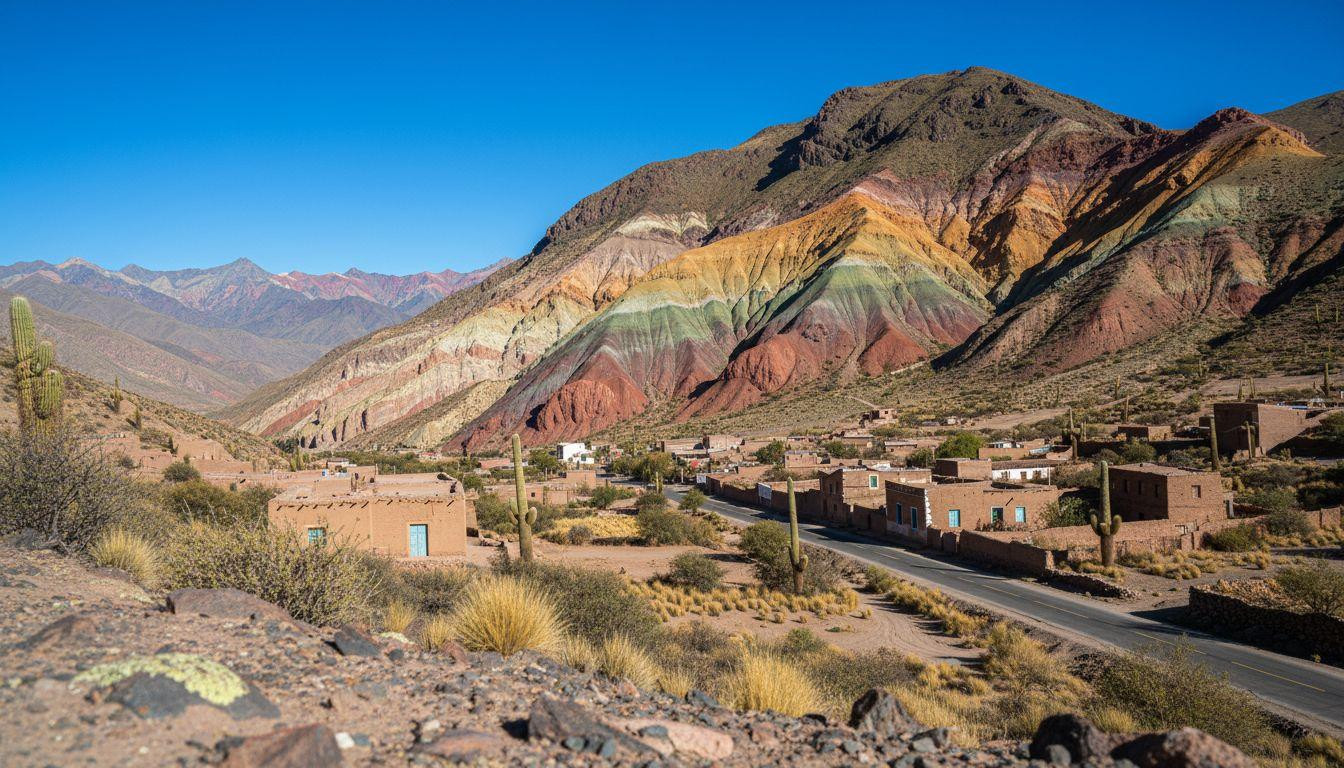
This northwestern Argentina valley reveals mineral-striped mountains where copper, iron, and limestone layers paint horizontal bands of red, orange, yellow, and green across cliff faces. Dawn light transforms the Cerro de los Siete Colores into a natural canvas that has guided travelers for thousands of years. The same Ruta 9 that winds through these chromatic peaks today follows the ancient Camino Real trade route where pre-Inca civilizations carried coca leaves and textiles between the Atlantic and Pacific.
UNESCO recognized Quebrada de Humahuaca in 2003 as a cultural landscape representing 10,000 years of continuous human passage. What started as indigenous hunting grounds became the Inca’s primary mountain corridor, then Spanish colonial pathway, and now Argentina’s most visually dramatic high-altitude drive. I spent three days here and the meditative rhythm of ascending through color-changing geology never lost its impact.
Where Earth’s minerals paint mountains
The valley’s famous colors emerge from sedimentary layers tilted by Andean tectonic forces over 75 million years. Green hues come from shale and copper oxide deposits dating back 600 million years. White limestone bands formed in ancient marine environments 400 million years ago.
Yellow sandstone contains sulfur compounds, while pink and red clay layers rich in iron oxide represent more recent geological periods between 1-4 million years old. Brown manganese streaks create the final accent colors that make Purmamarca’s Hill of Seven Colors instantly recognizable from miles away.
The Seven Colors of Purmamarca
Purmamarca village (population 1,000) sits directly beneath the most accessible colored mountain in the valley. Morning light between 7am and 1pm provides optimal illumination when shadows don’t mask the mineral striping. Similar to Kings Canyon’s granite walls, the horizontal banding creates natural art that changes throughout the day.
Hornocal’s Fourteen-hue secret
Serranía de Hornocal reaches 14,232 feet elevation with even more complex color patterns than Purmamarca. The viewpoint requires a 4WD vehicle for the final approach, but rewards visitors with panoramic views of multicolored peaks extending toward Bolivia. Locals call it the “Painter’s Palette” for afternoon light effects that create optical illusions across the layered strata.
The route humans never abandoned
Archaeological evidence confirms human presence along this valley for millennia, though the exact 10,000-year timeline remains debated among researchers. Pre-Inca Aymara communities established the trading patterns that the Inca Empire formalized into their Qhapaq Ñan (Camino Real) network during the 15th century.
Spanish colonizers maintained the route for silver transport from Potosí mines. Modern Ruta 9, paved during the 1930s-1960s, follows the identical path that connected distant cultures across the Andes. Like Peru’s Colca Canyon, this landscape preserves indigenous heritage alongside natural drama.
Pucará de Tilcara’s stone testimony
Tilcara’s pre-Inca fortress overlooks the valley from a strategic hilltop position. Excavated in the early 1900s and partially rebuilt in 2000, the site demonstrates advanced indigenous engineering. Stone walls follow natural terrain contours while providing defensive advantages and trade route surveillance.
Carnival and solstice rituals today
Humahueca Carnival occurs each February with pre-Lent dancing that blends Catholic and indigenous traditions. Pachakuti solstice ceremonies in June honor Andean seasonal cycles that predate European arrival. Local artisans still weave ponchos and create ceramics using ancestral techniques passed down through generations.
Driving through living history
Ruta 9 covers 93 miles from Purmamarca to Humahuaca town, ascending from 7,620 to 9,645 feet elevation. The narrow, winding road demands careful driving but offers pullouts every few miles for photography and altitude adjustment. Recent visitor surveys indicate that most travelers encounter minimal traffic, especially during shoulder seasons.
Adobe architecture dominates village centers with cactus-covered churches, cobblestone streets, and iron streetlamps that evoke colonial periods. The 17th-century Uquía chapel contains gold-leaf “angelitos” paintings that demonstrate European and indigenous artistic fusion.
When to drive the valley
May through September provides the clearest weather with daytime temperatures reaching 64-68°F and minimal rainfall. Unlike Cabo Pulmo’s seasonal restrictions, Quebrada de Humahuaca remains accessible year-round, though summer rains (December-February) can create muddy conditions on unpaved side roads.
Where geology meets everyday life
Purmamarca’s morning market operates beneath colored cliffs where vendors sell quinoa bread, llama meat empanadas, and handwoven textiles. Coca tea helps visitors adjust to altitude while supporting local customs. Families have operated these market stalls for decades, maintaining authentic regional cuisine and crafts.
The quiet between famous neighbors
While Salta’s Valles Calchaquíes attract wine tourists to crowded tasting rooms, Quebrada de Humahueca receives 30% fewer visitors despite UNESCO World Heritage status. Like Europe’s overlooked heritage villages, this destination offers authentic cultural experiences without commercial pressure.
Accommodation costs average 20-30% below Argentine national rates due to the region’s remote location. Hostels in Tilcara and Humahuaca charge $25-40 per night, while boutique posadas in Purmamarca range from $55-90 nightly. Local restaurants serve traditional Andean meals for $8-15, significantly less than tourist-oriented establishments in nearby wine regions.
Your Questions About Quebrada de Humahuaca Answered
How do I reach Quebrada de Humahuaca?
Fly to Buenos Aires, then connect to Salta (SLA) or Jujuy (JUJ) airports via 2-hour domestic flights costing $110-220. From Salta airport, drive 106 miles northeast via Ruta 9 (approximately 3.5 hours) to reach Purmamarca. Car rentals cost $45-65 daily in 2025, though public buses operate regularly for $22-35 per route.
When do the colors look most vivid?
Morning sidelight between 8am-12pm and late afternoon from 4pm-6pm provide optimal color saturation. Dry winter months (May-September) offer clearest atmospheric conditions with minimal dust or haze. Summer visits risk afternoon thunderstorms that obscure mountain views, though colors appear more saturated when wet.
Can I explore beyond the main road?
Hornocal viewpoint requires 4WD vehicles for the final 3-mile approach, with tours costing $35-55 per person. Pucará de Tilcara charges $8 entrance fees for hilltop fortress access and valley views. Garganta del Diablo gorge near Tilcara offers free hiking with secluded trails that locals recommend for afternoon exploration.
Evening light fades across Humahueca’s colored peaks as llama bells echo through villages where time moves at pre-Columbian rhythm. The minerals that painted these mountains over millions of years continue creating daily masterpieces for travelers who follow ancient paths through living geology.