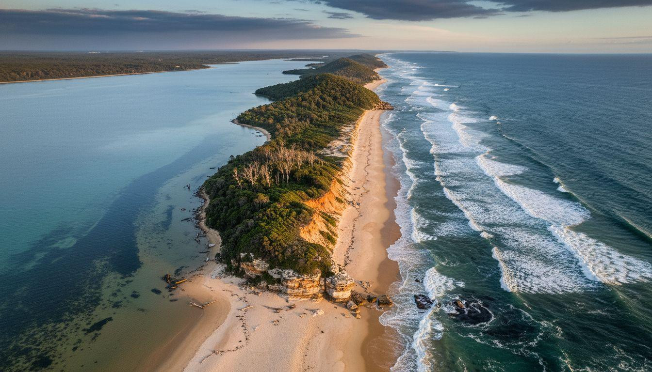
Dawn breaks at 6:42 AM over Cape Hawke as golden light reveals a geographic impossibility: an 5-mile peninsula so narrow that Pacific waves crash on one shore while glassy Wallis Lake mirrors sunrise on the other. This is Booti Booti National Park, where emerald coastal rainforest clings to sand dunes between two water worlds 175 miles north of Sydney. While 2 million tourists crowd Byron Bay annually, only 70,000 discover this Worimi sanctuary where Butibuti (plenty of honey) still describes the unhurried sweetness of mornings beneath paperbark trees and whale-watching winters from 735-foot cliffs.
Where ocean meets lake on Australia’s narrowest peninsula
The Lakes Way curves past Bulahdelah toward Forster-Tuncurry, where most travelers stop for oysters and move on. They miss the turnoff 12 miles north: a single road penetrating Booti Booti’s 6 square miles of peninsula wilderness.
This isn’t an island. It’s something stranger. Stand at Cape Hawke lookout and watch Pacific rollers pound eastern beaches while Wallis Lake’s turquoise surface remains glassy to the west.
Three hill complexes rise like ancient watchtowers above the narrow land bridge. Cape Hawke (735 feet), Booti Hill (554 feet), Charlotte Head (315 feet) create dramatic elevation changes across barely 1.2 miles of rainforest and dune. Geologically, this peninsula shouldn’t exist.
The timeless rhythm of Australia’s forgotten coast
Rainforest trails through paperbark and eucalyptus
Booti Booti’s coastal rainforest grows directly from sand, a botanical rarity along NSW’s exposed mid-north coast. Walking tracks wind through emerald canopies where paperbark trees shed cream-colored bark in long scrolls.
The contrast stuns: dense forest on a narrow spit, ocean roar filtering through leaves, sudden clearings revealing both lake and sea. Bird calls punctuate the silence as sea eagles overhead mix with woodland species in the canopy.
Three hill complexes connected by sand and story
The Worimi people knew this geography intimately before 1992’s park declaration preserved it. Cape Hawke’s 735-foot summit offers the revelation: 360-degree views showing exactly how improbably narrow this peninsula becomes. This village of 245 where whale sharks glide past white sand beaches sits 460 miles northwest, offering similar marine wildlife experiences.
The peninsula threads between water bodies like a natural causeway, vulnerable and magnificent. Recent visitor surveys show that most travelers discover the geography’s full drama only from this elevated perspective.
Winter whales and golden hour beaches
June to August migrations from coastal headlands
Winter transforms Booti Booti into Australia’s most accessible whale-watching sanctuary. Humpback whales migrate north past Cape Hawke from June through August, close enough to shore that binoculars reveal their slow breaches.
No $60-100 boat tours required. Just coastal walking tracks and patient observation from the 840-meter return Cape Hawke trail. Seven boat accessible Whitsunday coves require marine access; Booti Booti delivers whale encounters from solid ground.
Elizabeth Beach and The Ruins campground solitude
Elizabeth Beach curves along the ocean side: 6.8 miles of golden sand rarely crowded even in peak summer. The Ruins campground ($10-20/night) offers the rare gift of waking to wallabies near your tent.
Fresh oysters come from Forster’s working waterfront 20 minutes away. Local cafes serve $15-25 meals focused on Pacific seafood and lake prawns. Seven hidden wonders around Lake Argyle showcase Australia’s inland water drama; here, ocean and lake coexist within walking distance.
November spring: when wildflowers meet warming waters
Late spring (October-November 2025) delivers Booti Booti’s secret season: coastal heath blooms in purple and yellow, water temperatures rise to swimmable 68°F. Summer’s December-January school holiday crowds haven’t arrived yet.
Walking tracks remain empty during this balanced moment. Cape Hawke’s sunrise reveals luminous coastal colors without harsh summer glare. This is when the peninsula breathes its authentic rhythm, neither tourist season nor winter quiet.
Locals reclaim their mornings and nature performs for no audience. Seven coastal moments along this Australian drive offer dramatic scenery without Pacific Coast Highway crowds, complementing Booti Booti’s land-based sanctuary perfectly.
Your Questions About Booti Booti National Park answered
How do I reach Booti Booti from Sydney or Newcastle?
From Sydney: 4 hours north via Pacific Highway to Bulahdelah, then The Lakes Way toward Forster (175 miles total). From Newcastle: 1.5-2 hours north on same route (closer access).
No train service; car essential for park exploration. Nearest major airport: Newcastle (1.5 hours). Forster-Tuncurry offers accommodation base with 19,000 residents.
What’s the best time to visit?
Winter (June-August) for whale watching and solitude. Spring (October-November) for wildflowers and warming weather at 59-75°F. Summer (December-February) brings crowds and heat.
Avoid peak Australian school holidays (late December-January) when even this overlooked park sees visitor spikes.
How does Booti Booti compare to Great Lakes or Port Stephens?
Less crowded (70,000-100,000 annual visitors vs. millions at Port Stephens), more pristine rainforest. Peninsula geography creates unique visual drama that neither alternative offers.
Port Stephens provides more infrastructure and tours; Booti Booti offers authentic wilderness 12 miles from services. The narrow spit between two water bodies remains unmatched along Australia’s coast.
Morning light catches paperbark scrolls and turquoise water. Whales breach beyond the headland while a narrow peninsula holds what commercialized coasts have lost: the unhurried certainty that some places still resist the rush. Booti Booti exists in that rare gap between accessibility and obscurity, where Butibuti’s honey still tastes sweet.