South Rim Road closes to cars in November. The Park Service grooms the pavement for skis instead. Six miles of groomed track stretch from Gunnison Point to High Point Lookout, passing five overlooks where canyon walls drop 2,000 feet into silence. Winter entry costs nothing. Most visitors never know this exists.
The trail sits at 8,000 feet in western Colorado, 75 miles from Montrose. Snow depth varies: 2-4 feet at the trailhead, 3-5 feet mid-route, 1-3 feet at High Point where wind scours the ridge. Early April 2026 marks the season’s end. Historical data shows the trail closes by mid-April when base snow thins below 18 inches.
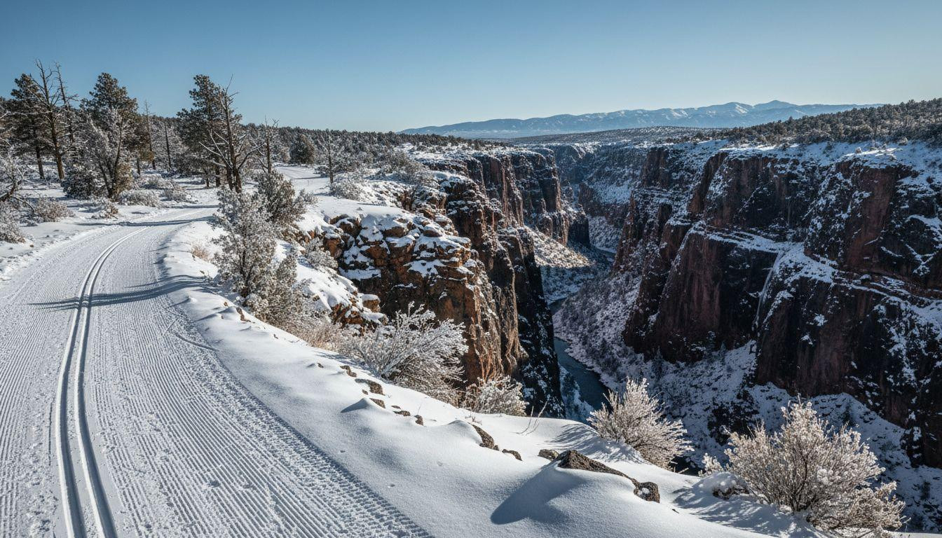
Gunnison Point to visitor center: where the trail begins
Parking sits 0.1 miles from the trailhead at 7,700 feet elevation. The visitor center operates year-round with limited winter services. Rangers groom tracks for both classic and skate skiing, conditions permitting. Snowshoers must stay off the groomed surface to preserve ski tracks.
The first overlook reveals 1,800 feet of canyon depth. Ravens circle below the rim. Elk tracks cross the snow near the edge. Captain John Gunnison’s 1853 expedition named this point during his survey of possible transcontinental railroad routes.
What makes this segment different
The groomed road starts here with fresh tracks most mornings after storms. Classic ski tracks run parallel to a wider skate lane. Wind exposure remains minimal compared to higher sections. This zone sees the most traffic, though “most” means fewer than 10 skiers daily during peak winter weeks.
Equipment and early decisions
No rentals exist within the park. Base Mountain Sports in Montrose charges $30-50 daily for adult classic ski packages. The 1.5-hour drive from town means bringing everything: water (no sources along route), layers for wind, skins for climbing sections. The gentle grade averages 500 feet gain over 6 miles, but rolling terrain adds 800 feet total elevation change.
Tomichi Point: first true canyon reveal
The trail reaches Tomichi Point at 1.5 miles and 7,800 feet elevation. Morning light hits east-facing walls here between 8-9am. The canyon measures 1,700 feet deep and 1,000 feet wide at this section. Precambrian gneiss formations, 1.7 billion years old, stripe the visible rock faces.
Tomichi Creek drainage gave this overlook its name. USGS maps from the 1950s first marked it officially. The point offers the first clear view of how snow transforms canyon geology. White accumulation highlights rock layers invisible during summer’s harsh light and heat haze.
Photography and visual elements
Crystalline winter air creates contrast impossible in warmer months. Long shadows stretch across the rim before 10am. The rust-red canyon walls against white foreground snow produce the trail’s signature image. Most skiers stop here for the first extended break, 45 minutes to an hour from the trailhead.
Pulpit Rock overlook: mid-route high point
Pulpit Rock sits at 2.8 miles and 8,232 feet, the trail’s highest elevation. Wind speeds average 20-40 mph at this exposed section. An eroded tuff spire gives the overlook its name. Snow accumulation stays lighter here due to constant scouring.
This marks the decision point for continuing versus turning back. The round-trip from here totals 5.6 miles, manageable for intermediate skiers in 3-4 hours. Pushing to High Point commits to 12 miles total. Weather can shift quickly at this altitude. Recent visitor reports note sudden squalls developing after 2pm.
Wind and weather considerations
NOAA data shows wind gusts reaching 50 mph during spring transition periods. Late March through early April brings temperature swings: highs of 25-40°F, lows of 5-20°F. The Park Service recommends turning back by 2pm to ensure daylight return. Sunset on April 5, 2026 occurs at 7:30pm MDT, but canyon shadows arrive earlier.
Chasm View: narrowest canyon section
At 3.8 miles and 8,100 feet, Chasm View overlooks the canyon’s 40-foot width. The 2,000-foot depth creates an almost claustrophobic vertical corridor. Safety barriers disappear under snow. Park regulations require staying 10 feet back from edges.
The Gunnison Gorge Group rock layers visible here formed 1.7 billion years ago. This geological formation represents some of North America’s oldest exposed stone. Winter conditions make the narrow chasm more dramatic. Snow on both rims creates a white frame around dark depths.
Depth and geological context
The extreme depth-to-width ratio defines Black Canyon’s character. Few canyons worldwide match these proportions. Summer visitors photograph this section most, but winter’s empty silence changes the experience entirely. Sound absorption in deep snow creates an eerie quiet absent during tourist season.
High Point lookout: trail terminus
The final 2.2 miles climb to 8,400 feet at High Point Lookout. A rock cairn marks the South Rim’s highest elevation. Views extend roughly 20 miles in clear conditions. The Gunnison River appears as a thin line 2,600 feet below.
Return requires the same 6-mile ski back unless shuttle cars wait. No commercial shuttle services operate. Some skiers place vehicles at High Point via East Portal Road if winter access permits. Descent takes 2-3 hours with gravity assistance. Total round-trip time runs 5-7 hours for intermediate skiers.
Summit experience and return logistics
The 360-degree panorama justifies the effort for experienced skiers. But the commitment level exceeds casual day trips. Cell service remains spotty throughout the route, with occasional single-bar reception at overlooks. Satellite communication devices provide backup. No emergency shelters exist between trailhead and terminus.
Planning your High Point ski journey
The season runs November through April, snow-dependent. Peak conditions occur January through February when base depth exceeds 3 feet consistently. Grooming happens 1-2 times weekly as ranger staffing allows. The Park Service posts current conditions via their mobile app.
Physical demands include 6 miles one-way, 500 feet net elevation gain, and 8,000-foot altitude. Beginners struggle with distance and elevation combined. Intermediate-plus skiers with backcountry experience handle the route comfortably. No food, water, or shelter exists along the way. Melting snow requires filtration.
Winter camping at South Rim Loop B costs nothing but offers no services. Montrose, 75 miles away, provides hotels and restaurants. The drive takes 1.5 hours via US-550. For context, Warner Point’s snowshoe trails offer shorter alternatives nearby.
Your questions about High Point ski trail answered
Is this suitable for beginners?
Grooming helps, but the 12-mile round-trip and 8,000-foot elevation challenge novices. Intermediate skiers with fitness handle it better. The gentle grade deceives: accumulated distance and altitude create fatigue. Rangers recommend starting with the 3-mile round-trip to Tomichi Point before committing to High Point.
Can you snowshoe instead of ski?
Yes, but park rules require staying off groomed ski tracks. Snowshoers must walk alongside the prepared surface. This adds difficulty in deep snow sections. Skiing covers the distance faster and more efficiently. Snowshoeing works better on shorter winter trails with dedicated snowshoe routes.
How does this compare to summer rim trail?
Same overlooks, zero vehicle traffic, different sensory world. Summer brings 500-plus hikers daily. Winter sees fewer than 10 skiers. The silence and solitude transform familiar views. Snow highlights geological features summer heat obscures. Free winter entry versus summer fees adds appeal. For comparison, other canyon destinations charge $35 year-round.
The return ski starts around 2pm for most parties. Tracks from morning ascent make descent faster. The parking lot sits empty except for a few cars. Wind picks up as afternoon shadows lengthen across the rim. Six miles of solitude earned, six miles of quiet glide back.