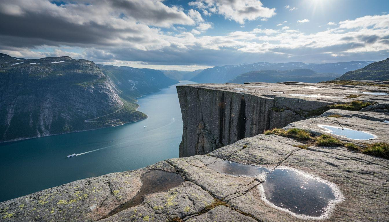
The granite edge at Preikestolen ends in a clean vertical line. Below it, 604 meters of empty air. Then Lysefjord’s water, shifting from pale turquoise near the shallows to deep blue where the fjord drops over 400 meters. You can see the color change from where you stand. The plateau measures 25 by 25 meters. No barriers. No ropes. Just rock and sky and the long drop into water you can trace with your eyes all the way down.
I arrived at the trailhead parking lot at 6am in early May. The lot holds maybe 200 cars. By 9am it fills completely. The hike starts at 270 meters elevation and climbs through mixed terrain for 4 kilometers. Wooden steps worn smooth by 300,000 annual visitors. Rocky sections where you pick your route. Patches of mud in spring when snowmelt runs across the path.
The vertical geography of Lysefjord
Lysefjord cuts 42 kilometers inland from Stavanger. Glacier-carved walls rise nearly straight from the water. At Kjeragbolten, the cliff face reaches 984 meters above the fjord. A 5-cubic-meter boulder sits wedged in a crevasse there. Below it, a 241-meter vertical drop, then another 735 meters of steep gradient to the water.
The scale breaks normal depth perception. From Preikestolen’s edge, ferry boats crossing the fjord look like white dashes on blue paper. The 27 hairpin bends of the Lysebotn road are visible as a pale thread against the far cliff. You can count them if the light is right.
Granite striations run vertically down the cliff faces. Dark bands where water seeps. Lighter sections where the rock stays dry. In morning light, shadows from the eastern cliffs create distinct color zones on the water below. The physics of looking straight down 604 meters makes your brain recalibrate what “far” means.
Stone meets water
What you see from the edge
The water color shifts based on depth. Pale turquoise marks shallows near the shoreline. Darker blue indicates the deep channel running down the fjord’s center. On calm mornings, the surface holds perfect reflections of the cliffs. Wind ripples erase them by mid-morning.
Cliff shadows move across the water as the sun tracks west. By 2pm in May, the entire eastern wall sits in shadow. The temperature differential between sun-exposed rock and shaded sections creates updrafts you can feel standing at the plateau edge. Similar dramatic coastal formations appear at Oregon’s basalt cliffs near Yachats, though those rise only 200 feet above the Pacific.
The sound of height
Wind rushes across the exposed plateau constantly. On calm days it’s a steady presence. When weather systems move through, gusts strong enough to lean into. The water sounds from 604 meters below don’t carry up. Occasionally a ferry horn echoes off the cliff walls. Mostly just wind and the scrape of boot soles on granite.
Early morning brings near silence. By 10am, voices from other hikers. By noon in summer, the plateau holds 50 to 100 people. Everyone gravitates toward the edge. Everyone looks down. The quiet returns after 4pm when most day hikers descend.
Standing above the fjord
Preikestolen’s 604-meter platform
The round-trip hike covers 7.6 kilometers with 334 meters of elevation gain. Most hikers complete it in 4 hours total. The trail alternates between wooden steps, packed dirt, and bare rock. Spring snowmelt creates muddy sections that dry by June. The final approach to the plateau is a gentle uphill walk across smooth granite.
The plateau itself is flat. Weathered rock with shallow depressions that hold rainwater. The edge is a clean break where the horizontal surface meets vertical cliff. People approach it differently. Some crawl to peer over. Others stand upright at the very rim. A few sit with legs dangling into space. There’s no official rule about how close you can get.
Kjeragbolten’s suspended reality
The hike to Kjeragbolten starts at Øygardstøl and covers 11 kilometers round-trip. Elevation gain reaches 570 meters over ridges and technical rocky sections. One section requires chains bolted into the rock for hand-holds. The boulder itself sits wedged between two cliff faces with 984 meters of air below it. Stepping onto it requires commitment. The rock is solid. The view is not.
Fewer people attempt Kjerag than Preikestolen. The trail is harder. The approach is longer. The final scramble to the boulder filters out casual hikers. Those who make it find a quieter experience. Similar elevation adventures exist at Colorado’s Ouray hot springs, though those trade vertical drama for thermal contrast.
The fjord below
From Preikestolen, the Lysebotn road’s 27 hairpin turns are visible against the southern cliff. Each switchback is a precise engineering solution to gaining 900 meters of elevation in 7 kilometers. The road closes in winter. Opens in May. Carries tourist buses and rental cars through summer.
Ferry boats cross the fjord on regular schedules. From 604 meters up, they leave white wakes that persist for minutes before the water smooths. On perfectly calm mornings, the reflections are so clear you see cliffs doubled in the water. Those conditions last maybe an hour after sunrise before wind picks up.
The temporal quality of light hitting vertical walls changes hourly. Early sun strikes the western cliffs first. By noon, direct light reaches the water. Late afternoon creates long shadows that climb the eastern wall. The color shifts follow the light. For broader Norwegian fjord comparisons, Geirangerfjord’s UNESCO-listed narrows offer different scale and accessibility.
Your questions about Lysefjord answered
When can you hike safely?
Preikestolen is accessible year-round. May through October offers the most reliable conditions. Winter hiking requires experience with snow and ice. The trail doesn’t close, but conditions become hazardous without proper equipment. Kjeragbolten’s season runs late May through October. The access road to the trailhead closes in winter. Spring snowmelt makes the rocky sections slippery through early June.
How crowded does it get?
Preikestolen receives over 300,000 visitors annually. Peak season runs July through August. Arriving before 8am provides relative solitude. By 10am the trail fills. Parking lot capacity is limited. Summer midday can mean waiting for spaces. Kjeragbolten sees significantly fewer hikers due to increased difficulty. Off-season visits in May or September reduce crowds by half or more.
Is this more dramatic than Geirangerfjord?
Geirangerfjord holds UNESCO status for its waterfalls and scenic ferry routes. It attracts cruise ships and heavy summer traffic. Lysefjord delivers rawer cliff drama and hikeable edges above 600 to 984-meter drops. Geirangerfjord is panoramic beauty accessed by boat. Lysefjord is vertical immersion accessed by trail. Different experiences. Both valid. Lysefjord requires more physical effort but offers direct engagement with the geology. The choice depends on whether you prefer viewing landscape or standing inside it.
The ferry back to Stavanger leaves at 4:30pm. Most hikers make it with time to spare. The plateau empties by 5pm. The granite holds afternoon warmth for another hour. Then the wind picks up again and the light goes gold on the western cliffs and the water below turns from blue to gray to black as the sun drops behind the ridge.