Highway 64 crosses the Little Colorado River 12 miles east of Cameron. Most drivers keep going toward Grand Canyon’s South Rim. Pull over at the overlook and you’ll see what 99% miss: aquamarine water cutting through red limestone 800 feet below. This is the Little Colorado River Gorge, a 58-mile canyon system on Navajo Nation land where five different routes descend to turquoise pools and a sacred confluence. February 2026 offers ideal conditions for the trails that drop into this overlooked corner of northern Arizona.
The overlook most visitors skip
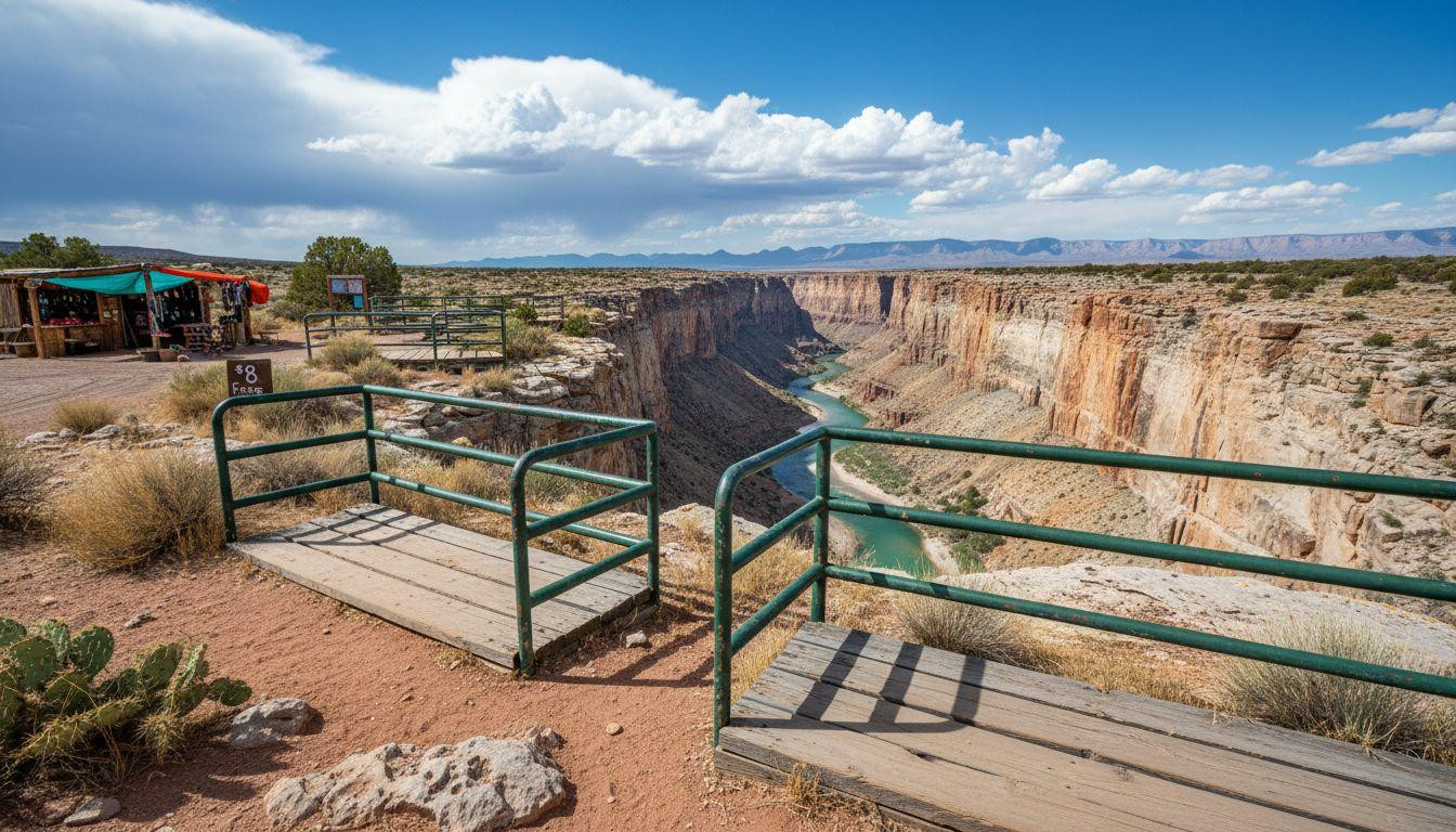
The Little Colorado River Overlook sits on Route 64 between Cameron and the Grand Canyon’s east entrance. Navajo vendors sell jewelry and fry bread at wooden stalls near the parking area. The overlook itself requires an $8 entry fee paid to the family managing access.
Metal railings line the rim where the gorge drops straight down. The Little Colorado River flows 800 feet below, its color shifting from turquoise to deep blue depending on calcium carbonate concentration. This is the same water that will join the Colorado River 57 miles downstream at a confluence sacred to Hopi, Navajo, and other indigenous communities.
The overlook sees maybe 100 visitors on a February day. Grand Canyon’s South Rim sees 12,000. The difference shows in the quiet and the absence of tour buses. Three wooden viewing platforms extend toward the canyon. Rocky terrain and uneven steps make wheelchair access difficult, but the view requires no hiking at all.
Five routes into the gorge
The Little Colorado River Gorge has no maintained National Park Service trails. Instead, five routes descend through Navajo Nation land or connect via Grand Canyon backcountry. Each requires different permits, fitness levels, and time commitments.
Salt Canyon Trail: the ancient Hopi route
The Salt Trail drops 2,900 feet over 3 miles from a trailhead reached via 15 miles of dirt road (Indian Route 6130 north of Cameron). This was the Hopi route to sacred salt deposits for thousands of years. Pictographs mark canyon walls where the trail passes.
The descent takes over 3 hours despite the short distance. Steep, eroded sections near the top require Class 2-3 scrambling. Cairns mark the route, but several cliff bands demand careful navigation. Around 250 hikers complete this trail yearly. Navajo Nation backcountry permits cost $15 per person and are described as easy to obtain through tribal offices in Cameron.
Horse Trail: the easier descent
The Horse Trail enters the gorge far upstream from the confluence. It drops 1,900 feet over 11.5 miles one-way, making it the gentlest grade of any route. Around 25 to 75 hikers use this trail each year.
The canyon floor stays dry for several miles after the descent. The Little Colorado River appears gradually, becoming a full perennial river several miles before Blue Spring. Swift water crossings and quicksand require attention. Hikers report needing a day or two from the Horse Trail to reach the turquoise water downstream. A brief section involves raw cliff exposure, but the route is considered far easier than Salt Canyon.
Beamer Trail: the National Park Service option
The Beamer Trail is the only NPS-maintained route to the Little Colorado confluence. It starts from Lipan Point via the Tanner Trail, covering 18 miles with 4,600 feet of elevation change. Fewer than 250 hikers complete this route yearly.
The trail is long, dry, and shadeless. Cairns guide you through small drainages as you wind toward the confluence. At 8.4 miles, a boot-beaten path branches to a river-level beach, the only camping spot without backtracking. A no-camping zone surrounds the confluence itself. The trail features narrow passages along exposed cliffs above the Colorado River. Grand Canyon backcountry permits cost $10 application fee plus $8 per person per night below the rim.
What makes the water turquoise
The Little Colorado River’s color comes from calcium carbonate deposits dissolved in the water. These minerals filter sediment and create the aquamarine hue visible from the overlook and intensifying near Blue Spring.
Blue Spring itself sits several miles upstream from the confluence. Water emerges from underground at a constant temperature around 50°F year-round. The spring feeds the river’s turquoise color, which becomes most vivid in the lower canyon sections. When the Little Colorado meets the Colorado River at the confluence, you can see the color contrast: aquamarine spilling into muddy green (assuming neither river is flash-flooding).
February offers clear water conditions. Summer monsoons turn the Little Colorado brown with sediment. Winter and early spring provide the best visibility for the turquoise phenomenon that makes this gorge distinct from other Arizona canyons.
Walking the canyon floor
The 58-mile gorge bottom has no maintained trail. Hikers pick routes along the shore, through dry wash, or directly in the river. Water depth and power increase downstream. Several miles before Blue Spring, the river becomes a full perennial flow requiring careful crossings.
Quicksand appears in sandy sections where water seeps through. Hikers report watching for wet sand that moves underfoot. The canyon walls narrow in places, creating shade and cooler temperatures than the rim. Red and tan limestone layers show millions of years of geological history. The silence is complete except for water and wind.
Camping is allowed along most of the canyon floor on Navajo Nation land (with permits) and in Grand Canyon backcountry (with NPS permits). The no-camping zone around the confluence extends roughly a quarter mile in each direction. Good camping spots exist on beaches and benches throughout the gorge. Water sources are reliable in the lower canyon but scarce in upper sections and on rim approaches.
Your questions about Little Colorado River Gorge answered
When is the best time to hike these routes?
February through April offers ideal conditions. Temperatures stay moderate (50s to 60s°F at the rim, 60s to 70s°F in the canyon). Summer heat makes the exposed trails dangerous, with canyon floor temperatures exceeding 100°F. Winter can bring snow to rim access roads. The turquoise water shows best when monsoon sediment clears, typically October through May.
Why is the confluence considered sacred?
The Little Colorado and Colorado River confluence is sacred to Hopi, Navajo, Zuni, and other indigenous communities. The Hopi Salt Trail led here for thousands of years. The turquoise water represents spiritual significance in traditional beliefs. Recent proposals to build a gondola carrying 10,000 daily visitors to the confluence have faced opposition from tribal communities protecting the site’s cultural importance.
How does this compare to Grand Canyon’s main corridor trails?
Grand Canyon’s Bright Angel Trail sees 500,000 hikers yearly. The Little Colorado routes combined see fewer than 1,000. Permits are easier to obtain and cost less ($15 Navajo Nation vs. $10 application plus $8 per night NPS). The trade-off is route-finding difficulty, exposure, and minimal infrastructure. Better than Zion where 500 hikers crowd slots and Muley Twist keeps 7 arches empty for $20, these routes offer solitude for experienced desert hikers.
The sun hits the overlook at 7am in February. The turquoise water 800 feet below catches the light and holds it. Three cars sit in the parking area. By 8am, most drivers have continued toward the Grand Canyon. The Little Colorado keeps flowing, aquamarine and quiet, through a gorge that asks for attention most travelers don’t give.