The I-90 exit appears at mile marker 45. Three miles up Forest Road 9030, a gate blocks the way. Beyond it, snow covers the asphalt. This is where the walk to Talapus Lake begins in winter, 50 miles east of Seattle.
The lake sits at 3,250 feet in the Alpine Lakes Wilderness. Summer brings turquoise water so clear you see rocks 15 feet down. Winter turns that clarity into ice-glass, frozen solid from late December through March.
Where the road ends and the basin begins
The gate at FR 9030 closes when snow arrives. That adds 3.2 miles of uphill road walking before the official trailhead. Most visitors park at the I-90 off-ramp and snowshoe the entire route, making it a 10.4-mile round trip instead of the summer’s 4 miles.
The road climbs through second-growth forest replanted in the 1960s after logging. Tall cedars and hemlocks line both sides. At 0.6 miles past the official trailhead, the forest shifts to older burn area from early 1900s fires. Charred snags still stand among the regrowth.
Talapus Creek runs downhill to the right of the trail. In summer it babbles constantly. Winter muffles it under snow and ice. The only sound becomes your snowshoe crunch and wind through evergreen tops.
The footlog crossing at the wilderness boundary
A single footlog spans Talapus Creek at mile 2.0 from the summer trailhead. This marks the Alpine Lakes Wilderness boundary, part of 394,000 protected acres designated for preservation. The log gets slippery with snow. Washington Trails Association crews installed turnpikes here to fight eternal mud.
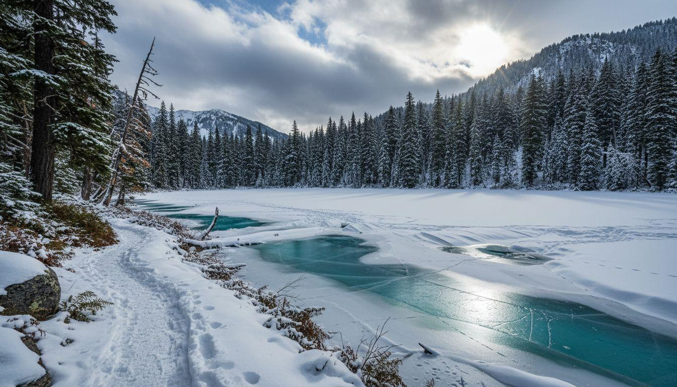
What the basin looks like when frozen
The lake appears through the trees suddenly. In winter, it’s a white oval surrounded by dark evergreens and basin walls. Snow covers most of the ice surface. Depth ranges from 2 to 8 inches depending on tree cover overhead.
The ice forms solid by late December. By February it holds weight easily, though caution near inlets and outlets remains necessary. Turquoise water shows through in spots where wind clears the snow.
The snowshoe walk through cascade silence
Winter transforms the trail into routefinding practice. Summer’s clear path disappears under snow. Markers exist but you need map and compass skills. Most visitors follow existing snowshoe tracks when available.
The moderate grade makes this accessible for beginners with proper gear. Total elevation gain runs about 900 feet from the summer trailhead, spread gradually over switchbacks. Add the road walk and you gain more, but the slope stays manageable.
What you actually do here
Most snowshoers reach the lake, spend 30 to 45 minutes at the frozen shore, then return. Some continue 1.4 miles further to Olallie Lake at 3,800 feet. That extension adds steeper climbing and crosses dilapidated boardwalks the WTA hasn’t fully repaired.
A Northwest Forest Pass costs $5 for the day or $30 annually. Purchase online or at North Bend vendors 14.5 miles west. No other fees apply. The wilderness prohibits bikes, motorized vehicles, and unleashed dogs.
Avalanche awareness matters on FR 9030’s switchbacks and near the lake shore. Check North Cascades Highway winter conditions and Northwest Avalanche Center forecasts before any February trip.
The gear list that actually matters
Snowshoes handle the road and trail. Microspikes work for icy sections. Bring map, GPS, and compass since trails vanish under snow. Temperatures in February average 20 to 35°F at this elevation. Layer accordingly.
No lodging exists at the lake. Dispersed camping is free with your pass but requires winter camping skills. North Bend motels 14.5 miles away run $100 to $200 per night. Most visitors day-trip from Seattle.
Why winter makes this different
Summer parking fills by midday. The lot holds maybe 20 cars and roadside overflow gets crowded fast. Families, first-time backpackers, and dog owners pack the trail. The WTA calls it one of the most popular beginner spots in the Alpine Lakes Wilderness.
Winter drops visitor numbers dramatically. Maybe 10 to 20 snowshoers on a weekend. Weekdays see even fewer. The frozen lake and snowy basin belong mostly to you.
Compare this to the Enchantments, where permits cost money and lottery odds stay low. Talapus requires no permit outside May through October. The 50-mile drive from Seattle beats the 100-plus miles to Enchantments trailheads.
Your questions about Talapus Lake answered
When is the lake actually frozen solid?
Late December through March shows consistent freeze. The lake sits mostly solid by mid-winter. Recent trip reports from December 2025 confirmed 2 to 8 inches of snow cover and frozen surface. Always test ice thickness carefully near moving water.
Can beginners handle this in winter?
Yes, with proper gear and awareness. The moderate grade and well-used route make it manageable. But winter adds routefinding challenges and avalanche risk. Check conditions, bring navigation tools, and understand basic snow safety before attempting.
How does this compare to summer crowds?
Dramatically quieter. Summer sees hundreds of hikers on peak weekends. Winter drops to dozens at most. The road closure filters out casual visitors. You trade easy access for solitude and frozen beauty.
Sunrise in February hits the basin around 7:30am. Pink light reflects off ice and snow. Your tracks stay first in fresh powder for hours. This is what the Cascades feel like when permits don’t matter and crowds stay home. The turquoise water waits under ice-glass, 50 miles from Seattle’s noise.