Route 923 cuts through empty highlands for 12 miles before the parking area appears. No signs, no facilities, just gravel and wind. February snow covers the basalt rim in white. Walk to the edge and the canyon opens below: black hexagonal columns rising 100 feet, turquoise water cutting through the center. The color exists only March through July, before glacial silt turns it gray.
Studlagil Canyon sits in East Iceland’s Jökulsá á Brú valley, 342 miles from Reykjavik and 19 miles from Egilsstaðir. A hydroelectric dam exposed the basalt walls in 2017 when water levels dropped. Photographer Einar Páll Svavarsson shared images that year. Tourism followed, but the remoteness keeps crowds low. Roughly 50,000 visitors arrive annually, compared to millions at South Coast sites like Reynisfjara.
The turquoise window closes in August
Glacial melt creates the color. Fine rock flour particles ground by ice scatter blue wavelengths while absorbing others. The Jökulsá á Brú River carries this sediment from May through September, peaking in early summer. Water glows brightest when melt accelerates but before late-season silt volume increases. By August, the turquoise fades to muddy gray as particles settle and flow dilutes.
Temperature matters. East Iceland averages 50-59°F in summer, with long daylight hours stretching past midnight in June. Spring arrives slowly: March through May brings 32-50°F temperatures and melting snow that swells side streams. Winter sees 23-32°F daytime highs, short 7-9 hour daylight, and frequent storms. February 2026 conditions make hiking risky without experience and gear.
The river discharges roughly 17,000 cubic feet per second during peak melt, carrying sediment concentrations of 15-22 pounds per cubic yard. This volume creates the visual intensity. Visit too early in spring and ice blocks trails. Visit too late in summer and the color disappears. The window matters.
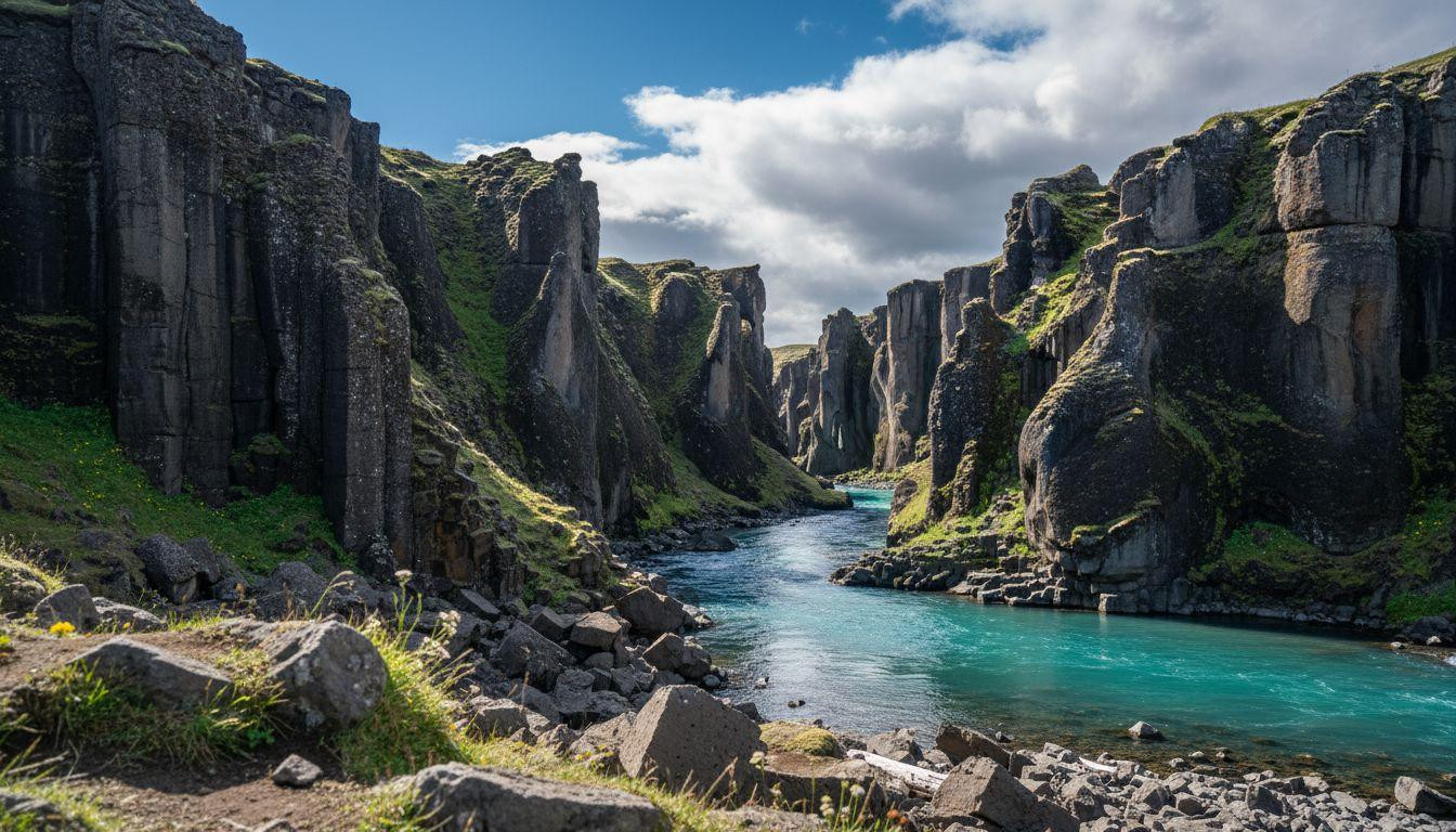
Black basalt columns that twist
Hexagonal formations bent by ancient pressure
Volcanic lava cooled rapidly thousands of years ago, fracturing into hexagonal columns as it contracted. Tectonic stress in the Jökulsá á Brú basin bent these formations unevenly, creating twisted shapes that line the canyon walls. Some columns rise 30 feet, others lean at angles. The geometry feels deliberate but formed without human touch.
The east side trail brings you close to the columns. Walk 1.2 miles on uneven gravel, gaining 500 feet in elevation. The path descends to river level where you can touch the basalt. Rough texture, cool even in summer. The west side offers a faster viewpoint from the clifftop, 0.8 miles round-trip with less elevation change. Both sides show the same canyon but different perspectives.
Comparison to Iceland’s other basalt sites
Reynisfjara on the South Coast draws tour buses daily to see black sand and sea stacks. Parking costs $5, crowds fill the beach by 10am, and dangerous waves kill tourists who ignore warnings. Studlagil has no fees, no buses, and no ocean. The experience feels quieter. For those seeking similar formations without the chaos, volcanic basins with black dacite spires offer comparable geology in remote settings.
What you actually do here
The hike and what to bring
The east side trail takes 1.5-2 hours round-trip, 2.5 miles total. Wear hiking boots with ankle support. The path crosses marshy sections in spring and icy patches in winter. Bring water, layers for wind, and a camera. No services exist at the trailhead. The nearest gas station sits in Egilsstaðir, 30 minutes away. A 4×4 vehicle helps but isn’t required May through September.
Park at the Stuðlagil Bridge lot (GPS: 65.1879375, -15.2854315). The trail starts behind the information board. Follow cairns when snow covers the path. Turn back if weather deteriorates. East Iceland storms arrive fast, dropping visibility to zero. Check road.is before driving Route 923 in winter. The road closes frequently November through April.
Where to eat and stay nearby
Egilsstaðir offers the closest lodging. Budget guesthouses run $100-150 per night, mid-range hotels $150-250, farm stays with breakfast $200-300. The town has three grocery stores and five restaurants serving lamb soup ($15-20), Arctic char ($25-35), and skyr yogurt desserts ($8-12). Möðrudalur farm, 25 miles north, serves traditional hangikjöt smoked lamb and rye bread in a historic setting.
No restaurants exist at the canyon. Pack food. Pink-footed geese nest along the river May through June, migrating from Greenland. Watch from a distance to avoid disturbing nests. For other remote East Iceland experiences, slot canyons requiring short hikes provide similar solitude.
The quiet that settles in
Most visitors arrive mid-morning and leave by 2pm. Come at dawn and the canyon belongs to you. Light hits the basalt at an angle, turning black columns charcoal gray. The river’s rush echoes off the walls. No cell service, no voices, just wind and water. This feels different from South Coast stops where buses idle and tour groups follow flags.
Winter transforms the scene. Snow covers the rim, ice forms along the river edges, and Northern Lights appear on clear February nights. The turquoise disappears but the geometry remains. Some prefer this version: stark, empty, timeless. Others need the color to justify the drive. Both experiences exist depending on when you arrive.
Your questions about Studlagil Canyon answered
How do I reach the canyon from Reykjavik?
Drive Route 1 (Ring Road) east for 7-8 hours, covering 342 miles. Turn north on Route 923 at the Jökulsá á Brú bridge. The final 12 miles are gravel. Alternatively, fly from Reykjavik to Egilsstaðir (1 hour, $100-150), rent a car ($100-200 per day for a 4×4), and drive 30 minutes to the trailhead. Gas costs roughly $2.50 per liter. Budget $80-100 for fuel round-trip from Reykjavik.
Why does the water change color?
Glacial melt carries fine rock flour particles that scatter blue light wavelengths, creating turquoise hues when sediment concentration peaks during May-July melt season. By August, increased silt volume and particle settling turn the water gray. The phenomenon depends on glacier activity upstream. Warmer summers produce more melt and brighter color early in the season. For similar water color contrasts, geothermal springs with constant flow offer year-round clarity.
How does this compare to Fjaðrárgljúfur Canyon?
Fjaðrárgljúfur sits on the South Coast, 2 hours from Reykjavik, with paved access and easy 1.2-mile viewpoint trails. It draws 200,000+ visitors annually due to proximity to Ring Road hotspots. Studlagil requires 7-8 hours driving, gravel roads, and sees 50,000 visitors. Fjaðrárgljúfur offers green mossy cliffs and a winding river. Studlagil delivers black basalt and turquoise water. Both are free. Studlagil feels emptier. For more under-the-radar East Iceland options, coastal villages with February fog provide similar remote atmospheres.
The ferry back to Reykjavik doesn’t exist. You drive the same road home. Most stop in Egilsstaðir for gas and coffee. The canyon stays in your head longer than the drive.