The ferry from Tenerife docks at San Sebastián de La Gomera after 50 minutes across Atlantic waters. Most passengers rush toward Valle Gran Rey’s beaches. The wise ones turn inland toward Garajonay National Park, where 15 million years of prehistory awaits on foot.
La Gomera shelters Europe’s last pristine laurel forest. This ancient ecosystem survived ice ages that wiped similar forests from continental Europe. UNESCO recognized Garajonay in 1986 as humanity’s living window into the Tertiary period.
A forest older than the Mediterranean
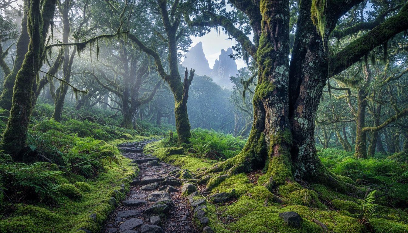
Garajonay National Park protects 9,756 acres of laurisilva forest dating back 15-40 million years. These laurel trees once covered Southern Europe and North Africa during the Tertiary era. Climate change eliminated them everywhere except the Canary Islands and Madeira.
The park encompasses 70% pure laurel forest across six municipalities. Canary laurel trees reach 130 feet in height, their trunks draped in ancient lichens. Morning mist feeds this ecosystem year-round, creating the “horizontal rain” that keeps 25% of flora and 50% of fauna endemic to this island.
Trade winds carry moisture from the Atlantic, condensing at 2,000-4,000 feet elevation. This creates the “monteverde” cloud forest effect. Temperatures stay cool at 54-59°F inside the canopy while coastal areas reach 77-82°F.
Where ancient trees meet ocean views
Laurel canopy trails
The Alto de Garajonay summit trail climbs 1,700 feet over 5.1 miles round-trip. Hikers pass through multiple forest zones, each supporting different endemic species. The trail requires 3.5-4 hours but rewards with panoramic views of five Canary Islands.
Moss carpets reach 6 inches thick on the forest floor. Ancient volcanic islands like Dominica share similar geological origins but lack La Gomera’s prehistoric forest ecosystem.
Coastal cliff paths
The Agulo coastal descent connects highland forest to Atlantic cliffs. This 3.3-mile trail drops 1,640 feet through multiple microclimates. Hikers experience the dramatic transition from cool, humid forest to warm, dry coastline within 2-2.5 hours.
Volcanic rock formations date back 12 million years. The Roques de Agando stand as jagged towers, remnants of ancient volcanic plugs. Guanche legends describe these formations as petrified warriors guarding the island’s sacred forests.
Trails that match every pace
Summit routes
The Vallehermoso forest loop offers 4.2 miles of gentle hiking through the park’s densest laurel sections. Elevation gain stays under 920 feet, making this accessible for most fitness levels. The trail passes traditional villages where terraced agriculture has thrived for centuries.
Endemic birds include the endangered Laurel Pigeon and Blue Chaffinch. Volcanic islands like Ischia offer unique natural phenomena but cannot match La Gomera’s ancient forest biodiversity.
Valley descents
La Fortaleza trail leads to a Guanche sacred site in 2.5 miles. This easy hike gains just 590 feet while revealing pre-Columbian ceremonial areas. Archaeological evidence shows indigenous peoples considered laurel forests spiritually significant for over 1,000 years.
Trail surfaces vary from thick moss to volcanic rock. Spring water sources appear every 0.6-1.2 miles along major routes. Similar Atlantic islands like Flores feature volcanic landscapes but lack the prehistoric forest experience.
An island that moves slowly
La Gomera’s 22,000 residents maintain traditional Canarian culture. Villages like Vallehermoso and Agulo preserve whitewashed architecture with red-tiled roofs. The island deliberately avoided mass tourism development, keeping authentic charm intact.
Silbo Gomero, the UNESCO-protected whistle language, still echoes across ravines. Locals use this ancient communication method spanning distances up to 3 miles. Traditional crafts include ceramics, embroidery, and palm honey production using methods unchanged for centuries.
Two new eco-lodges opened near Valle Gran Rey in 2025, emphasizing sustainability and local food sourcing. Traditional European villages offer cultural immersion but cannot match La Gomera’s combination of prehistoric nature and living heritage.
Your questions about this tiny island paradise for hikers answered
When should hikers visit La Gomera
October through May provides optimal hiking conditions. Temperatures stay comfortable at 61-75°F with 8-12 rainy days monthly. December offers the most dramatic mist effects in the laurel forest. Summer brings warmer weather but fewer crowds on trails.
How do visitors access trailheads
Car rental costs $38-49 daily for small vehicles with 3-day minimums. Ferry tickets from Tenerife cost $22-44 depending on season. Most trailheads lie within 6-18 miles of San Sebastián port. Public buses serve major villages but rental cars provide trail access flexibility.
How does La Gomera compare to Madeira hiking
Madeira’s laurisilva covers 37,000 acres versus La Gomera’s 6,800 acres of pure laurel forest. La Gomera offers 2.8 miles of trails per square mile compared to Madeira’s 1.7 miles density. A 3-day hiking trip costs approximately $460 in La Gomera versus $630 in Madeira.
Morning light filters through 130-foot laurel canopy as mist rises from volcanic soil. Endemic birds call across ravines where Guanche voices once echoed. In Garajonay, every footstep connects modern hikers to 15 million years of unbroken forest history.