Dawn breaks at 5:47 AM as your 4WD rounds a bend on the Old Telegraph Track, red dust rising behind while turquoise Coral Sea glows ahead. You’ve driven 889 miles from Cairns through creek crossings and tropical savannah to reach what maps call Cape York Peninsula. Australia’s northernmost continental point where fewer than 10,000 travelers venture annually.
While millions photograph Sydney’s harbor, this wilderness peninsula guards something rarer. 889 miles of challenging tracks leading to Pajinka, where two seas converge and civilization feels impossibly distant. This isn’t packaged Australian tourism. This is earned discovery.
Where red dust meets two seas
Cape York Peninsula extends like a geographical finger pointing toward Papua New Guinea. Its tip rests at 10°41’S latitude where Coral Sea’s turquoise meets Arafura Sea’s indigo. The journey from Cairns requires 7-12 days depending on conditions and skill.
The Old Telegraph Track, once the only route until 1986, delivers the peninsula’s most challenging crossings. Gunshot Creek, Palm Creek, Nolan’s Brook where water flows across road and mud threatens traction. Bypass roads now exist, but purists chase the OTT’s 37-mile southern section for authentic frontier experience.
At Bamaga, population 1,000, civilization thins to essentials before the final push to The Tip. Tasmania’s remote wilderness coastlines share this raw Australian character, but nothing matches Cape York’s isolation.
The 4WD journey that earns Australia’s northernmost point
The Old Telegraph Track challenge
Creek crossings define Cape York’s reputation. Water depth varies with season. Dry season (May-October) offers manageable 1-2 foot depths, but November’s wet season onset transforms tracks into impassable torrents.
The OTT’s northern 31-mile section features multiple creek fordings where approach angle, momentum, and vehicle clearance determine success or winch recovery. Locals recommend driving in convoy. Solo breakdowns mean satellite phone dependence and long waits.
Where wilderness remains genuine
Between Cooktown and The Tip, services vanish. Fuel at Bramwell Junction or Coen becomes critical planning. No roadside rescues exist for 125+ miles. Indigenous land requires permits through Northern Peninsula Area Regional Council for $20.
Wildlife encounters intensify: saltwater crocodiles inhabit coastal rivers, cassowaries cross rainforest tracks, wallabies appear at dusk. This isn’t styled adventure tourism. It’s genuine remote travel demanding preparation, mechanical competence, and respect for isolation.
At The Tip where tourism simplifies
Punsand Bay’s surprising comfort
After days of challenging tracks, Punsand Bay Private Campground delivers unexpected amenities. Beachside cabins ($65-120/night), hot showers, and pizza restaurant serving fresh seafood. The caravan park sits on pristine coastline where turquoise water meets white sand beaches.
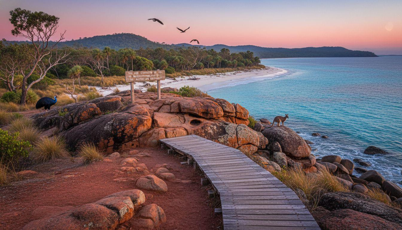
Most visitors camp ($8-24/night), trading luxury for location. From here, The Tip lies 3 miles north. Wooden walkways lead to the famous “You Are Standing at the Northernmost Point of the Australian Continent” sign overlooking rocky coastline where two seas converge visibly different blues.
Beyond the sign
Fly Point offers elevated views across Coral Sea. Fruit Bat Falls provides rainforest swimming holes at 75-77°F water temperature. Fishing charters chase barramundi and mud crabs.
But the essential Cape York experience remains simpler: morning coffee watching sunrise over water where next landmass north is Papua New Guinea, 93 miles distant. The satisfaction isn’t the sign. It’s the 889 miles that earned reaching it.
Australia’s remote wilderness sanctuaries share this raw beauty, but Cape York’s combination of challenge and reward remains unmatched.
The contrast nobody photographs
While Instagram fills with Bondi Beach crowds and Uluru sunset tours, Cape York’s isolation remains genuine. The 6,000-10,000 annual visitors represent 0.2% of Great Barrier Reef tourists. No shuttle buses, no paved parking lots, no WiFi at The Tip.
Just red dirt tracks through country that hasn’t changed significantly since the telegraph line opened communication in 1887. The peninsula’s 1,000 scattered residents maintain Indigenous cultural sites, operate essential services, and watch weather patterns that dictate when roads close.
Recent visitor surveys reveal average expedition costs of $1,100-1,500 for 10-day self-drive journeys. Overlooked scenic drives worldwide offer similar crowd-free experiences, but few demand Cape York’s level of preparation and commitment.
Your questions about Cape York’s 4WD journey answered
When can you actually drive there?
Dry season (May-October) provides reliable access. Daytime temperatures 77-86°F, minimal rain, creek depths manageable. November-April wet season closes most tracks as monsoonal rainfall makes crossings impassable and flooding isolates communities.
Tour operators concentrate June-September when conditions peak. Solo travelers need high-clearance 4WD, recovery gear (winch, snatch straps, shovel), spare fuel capacity, and mechanical competence. Satellite phone or EPIRB emergency beacon essential.
What does Cape York actually cost?
Camping dominates accommodation: $8-24/night at established sites, free bush camping permitted in designated areas. Punsand Bay cabins $65-120/night. Fuel costs spike. Diesel prices 20-40% above Cairns rates at remote stations.
Total expedition costs vary: $1,100-2,400 for 10-day self-drive journey including fuel, food, camping, permits. Guided tours $2,400-4,800 cover logistics, meals, expertise. Queensland’s geological wonders offer complementary adventures from the Cape York region.
How does it compare to other wilderness drives?
Both Cape York and Iceland’s Ring Road deliver frontier driving experiences, but Cape York demands higher skill. Iceland’s Ring Road is paved, serviced, tourist-infrastructure supported. Cape York requires genuine 4WD capability, self-sufficiency, and wilderness competence.
Iceland welcomes 2+ million tourists annually; Cape York sees fewer than 10,000 at The Tip. The remoteness isn’t marketed atmosphere. It’s geographical reality requiring preparation and respect.
At 5:47 AM, steam rises from your camp coffee while crimson light touches the place where Coral Sea meets Arafura Sea. The 4WD’s dust-covered panels tell yesterday’s creek crossing stories. Ahead, the track leads south. 889 miles of red dirt memory between you and Cairns civilization. Nobody photographs this moment. You earned it.