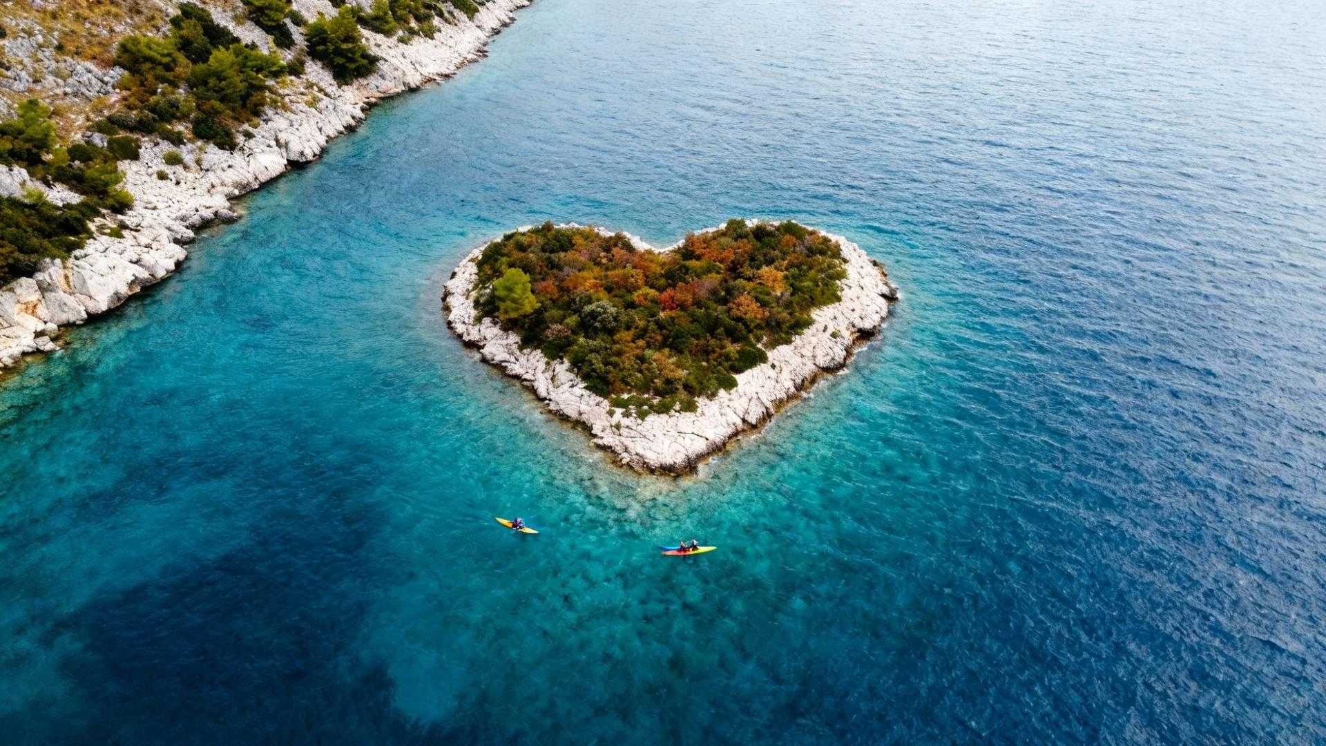
I’ve spent two decades exploring more than 900 islands scattered across the Adriatic, from Italy’s forgotten limestone stacks to Albania’s wild coastlines. But nothing prepared me for the moment our boat rounded Pašman Channel and I saw Galesnjak from above through a friend’s drone camera. This 0.132-square-kilometer Croatian islet forms a perfect natural heart shape that Napoleon’s cartographers first mapped in 1806, yet somehow it remains one of the Mediterranean’s most protected secrets.
While Santorini drowns under 17,000 daily tourists paying €300+ for cliffside rooms, Galesnjak beats quietly with zero permanent residents and no hotels. The island earned its “Lovers’ Island” nickname not from commercial romance packages, but from geology that carved Mediterranean vegetation into symmetrical love geometry 7,000 years ago when Neolithic people first walked its shores.
Local fishermen from nearby Turanj call it “naše krhko srce” — “our fragile heart” — and they mean it literally. When Google Earth spotlighted this formation in 2009, triggering features on CNN and ABC, boat traffic increased 300%. Now Croatian maritime authorities quietly restrict anchoring to protect the coastline’s 1,545-meter perimeter from erosion that threatens to blur the heart’s perfect edges.
The geological accident that created Mediterranean’s only heart island
How limestone erosion carved symmetrical romance
Galesnjak sits in the Pašman Channel where Adriatic currents carved softer limestone around harder dolomite cores over millennia. The island’s maximum elevation reaches just 36 meters, but from that height you can see how wave action sculpted two symmetrical lobes separated by a perfect cleft. University of Zadar archaeologists discovered that Galesnjak connected to neighboring Ričul via a stone causeway built 6,100-5,400 years before Christ, suggesting ancient inhabitants recognized something special about this geography long before satellites did.
Why Napoleon’s cartographers mapped it first
The 1806 Atlas of the Dalmatian Coast shows Galesnjak’s distinctive shape when most Adriatic islands appeared as simple ovals. French military surveyors needed precise coastal maps, and this heart formation served as a navigation landmark for ships entering Zadar’s harbors. Pope Alexander III reportedly admired the island in 1177 while waiting for news from Zadar, though medieval records described it simply as “the small wooded isle” without recognizing its romantic outline visible only from above.
The Instagram paradox locals actually fear
Why fame threatens the heart’s perfect geometry
When the Huffington Post declared Galesnjak “the World’s most adorable island” in 2009, boat operators in Biograd na Moru saw 400% booking increases within months. The Jureško family, who owns the island, offered part of it for sale at €10 million in 2023 with wedding venue plans, but Croatian agricultural land restrictions prevented development. Local environmental groups argued that protecting pristine Adriatic formations matters more than commercial tourism infrastructure.
The protection rules that keep crowds away
Unlike Hvar’s 300+ daily ferry arrivals, Galesnjak has no dock or official landing sites. Visitors must arrange private boats from Turanj or Pašman Island, typically costing €50-100 per group for the 20-minute crossing. Maritime authorities enforce no-anchoring zones within 50 meters of the shoreline during nesting season (April-July), and the island’s classification as agricultural land prevents any permanent structures. You can walk the entire heart-shaped coastline in under 10 minutes, but you cannot build, camp, or even light fires on the Mediterranean scrubland that covers its olive groves.
How October delivers the perfect visiting window
Why shoulder season beats summer crowds and waves
Summer’s peak tourism brings choppy Adriatic conditions and sea temperatures hitting 26°C that limit comfortable exploration time. October drops air temps to 18-22°C with calmer seas and 60-70% fewer tourists than July-August peaks. Boat operators reduce rates 30-40% after September, and the earlier sunset around 6:30pm creates golden-hour lighting that makes the heart shape more visible from elevated viewpoints on neighboring Pašman Island.
The November deadline before winter closes access
Local boat services typically suspend Galesnjak trips by mid-November when bora winds exceed safe navigation limits in the Pašman Channel. Croatian meteorological data shows storm frequency increases 400% between November-March, making the next four weeks the final opportunity until spring. This natural access limitation actually protects the island — winter’s human absence lets migratory bird species use Galesnjak as a staging point along Adriatic flyways without disturbance.
The Dalmatian alternative to Greece’s romantic chaos
Authentic Croatian island culture beyond Galesnjak
While you cannot stay overnight on the heart-shaped island itself, nearby Pašman offers traditional konobas serving fresh Adriatic fish that locals actually eat. The village of Tkon hosts September’s Fisherman’s Night festival where families demonstrate 500-year-old net-weaving techniques, and Biograd na Moru’s October Boat Show celebrates Dalmatian maritime heritage without the cruise ship crowds overwhelming Dubrovnik. Visit nearby island communities where stone-by-stone construction traditions survive.
Comparing costs to commercialized romance destinations
A Santorini caldera-view hotel averages €300-500 per night in shoulder season, while Pašman guesthouses cost €60-80. Galesnjak boat tours run €50-100 total versus Capri’s Blue Grotto at €180 per person. The entire Croatian experience — Split flights, boat access, authentic island meals — typically costs 60% less than equivalent Greek island tourism while offering undiscovered Balkan sanctuary experiences without manufactured romance packages.
Your questions about Croatia’s heart-shaped island
Can you actually land on Galesnjak Island?
Yes, though the island remains privately owned by the Jureško family with no official facilities. Boat operators arrange brief landings for photos, typically 20-30 minutes, respecting agricultural land restrictions that prevent camping or fires. Some tours simply circle the island for aerial-perspective photos from elevated vantage points on neighboring islands.
When did Galesnjak become Instagram famous?
Google Earth featured the island in February 2009, triggering immediate viral spread across social media and traditional news outlets. However, the heart shape was documented in Napoleon’s 1806 Atlas of the Dalmatian Coast, and Pope Alexander III noted the island’s distinctive appearance in 1177 — it took satellites to reveal what ancient observers could not see from sea level.
What’s the best way to photograph the heart shape?
The perfect heart outline appears only from elevated angles. Boat operators recommend October’s 6:30pm sunset from viewpoints on Pašman Island’s eastern hills, approximately 200 meters elevation. Drone photography requires Croatian Civil Aviation Agency permits, and operators emphasize respecting no-fly zones during April-July bird nesting seasons when migratory species use the island.