I nearly drove past it. Mile marker 45.3 on Highway 1, where a weathered pullout barely fits three cars. While Yosemite’s parking lots overflow with 4.5 million annual visitors battling for $35 entry and shuttle bus chaos, I stood alone at Hurricane Point as October’s golden hour painted the Pacific in copper and gold. The only sound? Waves crashing 500 feet below against cliffs where ancient redwoods somehow cling to vertical stone.
Big Sur doesn’t advertise itself. This 100-mile stretch of California coastline between Carmel and Hearst Castle remains what mass tourism forgot—pristine wilderness where you’ll spend $0 on entrance fees while national parks drain your wallet and patience.
October unlocks Big Sur’s secret advantage. Summer’s notorious fog lifts, revealing 75-80°F afternoons and crystal-clear Pacific views that July’s 60-degree mist conceals. The post-Labor Day exodus means you’ll claim viewpoints alone during weekday mornings, a luxury impossible three months earlier.
The crowd mathematics that change everything
Yosemite’s infrastructure groans under visitor pressure—6,500 parking spots vanish before 9am on summer weekends, forcing arrivals into hours-long shuttle queues. Big Sur operates differently. Highway 1’s natural design disperses travelers across dozens of unmarked pullouts, eliminating the parking lot nightmares plaguing California’s famous parks.
Why October delivers what summer cannot
Vehicle counts at Big Sur River Bridge hit 6,500 daily cars during peak season, creating gridlock at popular spots like Bixby Bridge and McWay Falls. October weekdays? That number drops 70%, transforming frantic photo-grabbing into meditative coastal exploration. I watched sunrise from Nepenthe’s terrace with three other people—a scene unthinkable in July when 200 tourists jostle for the same view.
The pricing advantage nobody mentions
National parks justify their $35 entrance fees with maintained facilities and ranger programs. Big Sur charges nothing while delivering superior natural drama. Those savings extend beyond entry—October hotel rates in Carmel-by-the-Sea drop 40% from summer peaks, and last-minute bookings become possible instead of requiring six-month advance planning.
The coastal phenomenon Yosemite cannot match
Yosemite offers granite grandeur. Big Sur counters with something geologically unique—the only California coastline where ancient redwood forests meet 300-foot ocean cliffs. This collision of ecosystems creates landscapes impossible elsewhere in the state.
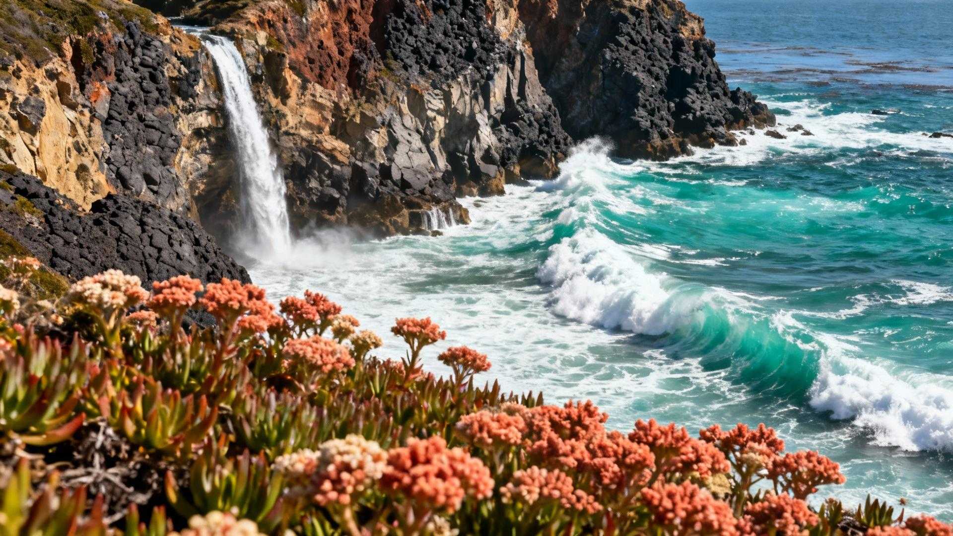
McWay Falls defies California geography
Only one year-round waterfall in California plunges directly into the Pacific Ocean. McWay’s 80-foot cascade onto remote beach sand represents a rare coastal phenomenon, yet it requires zero hiking to witness. Julia Pfeiffer Burns State Park’s overlook sits 50 yards from Highway 1 parking—accessibility national parks can’t replicate with their mandatory shuttle systems and mile-long trailhead walks.
Bixby Bridge engineering tells California’s story
Completed in 1932, this 714-foot concrete arch suspended 260 feet above Bixby Creek represented Depression-era ambition. Highway 1’s completion connected California’s isolated Central Coast after decades of mule-trail isolation. Standing beneath its span at dawn, watching fog drain through the canyon, you’ll understand why this coastline inspired Henry Miller and Jack Kerouac to abandon cities for Big Sur’s creative solitude.
October’s wildlife advantage worth timing for
Summer visitors miss Big Sur’s ecological peak. October initiates gray whale southern migration, bringing 20,000 cetaceans past these cliffs through January. Elephant seals begin breeding season displays at Piedras Blancas, creating beach drama invisible during summer months.
The monarch butterfly phenomenon
Pacific Grove’s eucalyptus groves host tens of thousands of migrating monarchs from October through February. This spectacle occurs 15 minutes from Big Sur’s northern entrance, yet summer tourists completely miss the butterfly clustering that transforms trees into living orange tapestries.
Sea otter viewing reaches perfection
Calmer fall waters improve wildlife spotting dramatically. California sea otters—once hunted nearly to extinction—thrive in Big Sur’s kelp forests. October’s reduced wind chop means binoculars reveal otter families floating in rafts, cracking abalone against chest-stones with techniques passed through generations.
The hidden viewpoints Instagram hasn’t ruined yet
Social media destroyed certain Big Sur spots—Pfeiffer Beach now requires $15 parking and 14-passenger shuttle vans during peak season. But locals protect lesser-known pullouts through deliberate obscurity, refusing to geotag locations that maintain their pristine solitude.
Hurricane Point View rewards early risers
Mile marker 45.3 lacks official signage, deterring casual tourists. Arrive at 7am when fog retreats from mountain ridges, revealing 15 miles of undeveloped coastline curving south toward Point Sur Lightstation. This viewpoint appears in zero guidebooks—exactly why it stays empty while Bixby Bridge parking overflows.
The Little Sur River Beach secret
Unmarked turnout at mile marker 66.5 provides beach access via steep 10-minute trail. October’s lower tides expose tide pools locals monitor but rarely photograph publicly, protecting this micro-ecosystem from Instagram’s destructive attention. Respect their silence—the California coastal preserve locals don’t want tourists to discover demonstrates why some places deserve protective obscurity.
Practical logistics for October perfection
Big Sur sits 3 hours south of San Francisco, 2 hours from Monterey Regional Airport. Base yourself in Carmel-by-the-Sea for charming accommodations or Big Sur Village for rustic forest lodges.
Timing your golden hour perfectly
October sunsets occur around 6pm, painting western cliffs in amber light that photographers dream about. Unlike this hidden Seattle neighborhood has better coffee than Pike Place where timing matters for cafe culture, Big Sur’s lighting demands precise scheduling. Arrive 30 minutes before sunset for optimal positioning without crowds.
Weather realities require preparation
Highway 1 closes during winter storms—November rains create mudslides that strand travelers for weeks. October’s 2-week dry window between summer fog and winter precipitation represents Big Sur’s most reliable weather pattern. Check Caltrans conditions before departing, as 6.8 miles remain closed at Regent’s Slide requiring inland detours.
The conservation ethic worth respecting
Big Sur operates without centralized management—fragmented jurisdiction among federal, state and private landowners creates preservation through complexity. This chaotic protection worked better than any national park designation possibly could.
Why locals guard their coast fiercely
Monterey County receives 4-5 million annual visitors generating $3 billion in tourism spending, yet Big Sur residents actively discourage social media promotion. They’ve watched Instagram destroy once-pristine spots through geotagging—Pfeiffer Beach’s purple sand now requires paid parking and shuttles because viral posts overwhelmed its delicate access.
Your role in Big Sur’s future
Practice invisible tourism. Pack out trash, stay on marked trails, avoid geotagging hidden spots, and support local businesses that prioritize conservation over profit. Better than Patagonia: these Pakistani lakes have turquoise water and roadside access demonstrates how responsible tourism preserves destinations—Big Sur deserves the same protective approach from visitors who understand that some places stay magical precisely because they resist commodification.
Yosemite will still be there next year, crowds and all. Big Sur’s October window won’t wait—November rains close Highway 1 sections unpredictably, and by spring the tourist tide returns. Skip the national park chaos this fall. Point your car south on Highway 1, claim an empty pullout at golden hour, and discover why California’s most dramatic coastline remains its best-kept secret.
Your Big Sur questions answered
Is Big Sur accessible without hiking experience?
Absolutely. Highway 1’s best viewpoints require zero hiking—McWay Falls overlook sits 50 yards from parking, Bixby Bridge viewpoint involves a 30-second walk, and Hurricane Point requires only stepping from your car. Physical limitations don’t prevent experiencing Big Sur’s coastal drama, unlike Yosemite’s trail-dependent attractions.
What makes October specifically better than summer?
Three factors converge: 75-80°F temperatures replace summer’s 60-degree fog, 70% fewer visitors eliminate parking struggles, and wildlife migrations peak with gray whales and monarch butterflies. Summer visitors spend half their time waiting for fog to lift—October delivers consistently clear conditions.
Can I visit Big Sur as a day trip?
Yes, though overnight stays maximize the experience. San Francisco visitors should depart by 7am to reach Big Sur by 10am, allowing 6 hours of exploration before returning. Monterey-based travelers enjoy more flexibility with only 90 minutes driving time each direction.
Are there cell service and facilities?
Cell service vanishes between Carmel and San Simeon—plan accordingly. Gas stations exist only at Big Sur Village (mile marker 37) and Ragged Point (mile marker 75). Restaurants cluster near Big Sur River Inn, Nepenthe and Lucia, but expect long waits during meal times even in October.
How do I respect local conservation efforts?
Avoid geotagging specific locations on social media, pack out all trash, stay on designated trails, and support businesses displaying conservation commitments. Big Sur’s fragility requires visitor restraint—treat every pullout like the protected wilderness it technically represents, even without official park status.