“`html
South Rim Road closes to vehicles in mid-November. Snow transforms the asphalt into a 6-mile snowshoe trail leading to Warner Point, the highest overlook in Black Canyon of the Gunnison National Park at 8,000 feet. By late March 2026, the packed snow gives way to mud and ice patches, but the road stays closed until late April. This window offers something rare: canyon solitude earned through effort, not luck.
The trailhead sits 15 miles from Montrose. Drive to the South Rim Visitor Center, park in the 50-vehicle lot, strap on snowshoes. The 12-mile round trip (6 miles road, 0.4 miles trail) takes 5-7 hours depending on conditions. Most visitors turn back after the first mile. The ones who continue find the canyon’s deepest views without crowds.
South Rim Road approach: where asphalt becomes snowfield
The winter gate at Gunnison Point marks the transition. Beyond it, the road belongs to snowshoers and cross-country skiers from November through April. Park Service grooming keeps the surface packed early season, but by late March the snow thins to scattered drifts. Mud replaces powder. Ice lingers in shaded sections.
The 6-mile approach gains 500 feet gradually. Pinyon pine and Utah juniper frame the road, their resin scent sharp in cold air. Sagebrush pokes through melting snow. The forest canopy covers maybe 30 percent of the route, offering brief shade before opening to full sun exposure at 8,000 feet.
Bring 3-4 liters of water. Altitude dehydration hits harder than the cold. A local snowshoe outfitter who has guided this route for a decade confirms that most first-timers underestimate the sun’s intensity at this elevation. No shade means no escape from UV reflection off remaining snow patches.
Warner Point trailhead: highest parking at 8,000 feet
The road ends at a small pullout. No facilities, no restrooms beyond the visitor center 6 miles back. The Warner Point Trail starts here, a short 0.8-mile round trip gaining 50 feet to the overlook. After the long road approach, this final section feels almost ceremonial.
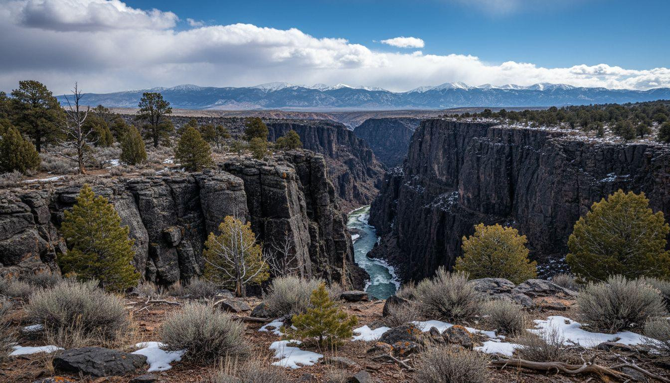
The trailhead sits at the canyon’s westernmost point. Views open in three directions: west toward the San Juan Range, north to the West Elk Mountains, south across the Uncompahgre Plateau. Mount Sneffels rises 40 miles southwest at 14,150 feet. Mount Emmons stands 30 miles northeast at 13,493 feet. Warner Point’s 8,000-foot elevation makes these distant peaks feel closer than they are.
Check weather before committing to the final trail segment. Winds at the exposed rim average 10-20 mph, stronger in afternoons. Spring storms roll in fast. Rangers at the visitor center track conditions daily, posting updates on the winter closure status board.
Pinyon-juniper forest section: where snow muffles sound
The trail cuts through sparse woodland. Pinyon pine needles carpet the ground, their scent mixing with juniper’s earthier notes. In winter, snow dampens every sound except wind through branches. Wildlife tracks cross the path: deer, coyote, occasional elk prints heading toward the rim.
The forest opens to sagebrush clearings every few hundred feet. These gaps offer glimpses of the canyon’s black schist cliffs before the trail curves back into trees. No benches mark the route, but flat rocks provide rest spots. The gradient stays gentle, undulating rather than climbing.
Temperature drops 5-10 degrees in shaded sections compared to open trail. March highs reach 40-50 degrees Fahrenheit at midday, but mornings start near 20 degrees. Layer accordingly. The forest’s sparse canopy means sun exposure dominates even in tree cover.
Western canyon narrows: where black cliffs drop 2,600 feet
The trail emerges at the rim. No railings, no barriers. Black gneiss cliffs plunge 2,600 feet to the Gunnison River below. The canyon narrows here to roughly 1,100 feet across, creating a visual funnel that draws the eye down to the water.
The rock is Precambrian gneiss, metamorphosed 1.7 billion years ago. Its dark color absorbs light, making the canyon walls appear almost charcoal in flat midday sun. Morning and late afternoon light reveal subtle striations: bands of lighter schist cutting through darker layers.
Stand back from the edge. Wind gusts push unpredictably at exposed points. The Park Service emphasizes personal responsibility here. No signs, no warnings beyond the visitor center briefing. Just open rim and gravity.
Gunnison River view: where winter ice echoes from below
The river runs 2,600 feet below, reduced to a silver thread from this height. Winter flow drops to 200-500 cubic feet per second, a fraction of spring runoff’s 10,000-plus. Ice jams form in shaded bends, visible with 10x binoculars as white patches against dark water.
Sound carries strangely in the canyon. River noise echoes off vertical walls, amplified and distorted. On still mornings, you can hear water moving from the rim. Afternoons bring wind that drowns everything else.
Temperature inversion creates a 20-40 degree gradient between rim and river. The canyon floor stays warmer in winter, trapping heat between walls. From 8,000 feet, the river exists in a different climate zone entirely.
Mountain panorama: where San Juans meet West Elks
Warner Point offers 360-degree views. West: San Juan Range peaks snow-capped through May. North: West Elk Mountains rolling toward Crested Butte. East: plains stretching toward Gunnison. South: Uncompahgre Plateau’s mesa formations.
Sunrise hits the rim around 6:45am in late March, painting the canyon walls orange before full light. Sunset comes near 7:15pm, casting long shadows across the river far below. Mornings stay clearer than afternoons, when clouds build over the mountains.
Weather changes fast at 8,000 feet. Blue skies can turn to snow squalls in an hour. Check forecasts, but trust what you see. If clouds mass over the San Juans, head back. The 6-mile road return takes longer than expected when conditions deteriorate.
Planning your winter Warner Point journey
Base in Montrose, 15 miles from the park. Hampton Inn runs $150 per night in March 2026, Red Arrow Inn $100, Comfort Inn $120. Snowshoe rentals cost $20-25 daily at Black Canyon Adventures or Gravity Sporting Goods. Park entry: $30 per vehicle, valid seven days.
Total cost for a solo two-day trip: $250-350 (lodging $120, snowshoe rental $50, entry $30, meals and gas $50-100). Cheaper than comparable canyon overlooks in Utah that charge $135 for crowded rim access.
The South Rim Road closure typically ends late April when snow clears. Late March through mid-April offers the best shoulder season window: minimal snow depth, longer days, fewer visitors than summer’s 300,000 annual park total. Warner Point sees maybe a few thousand visitors yearly, most in summer when the road opens to vehicles.
Your questions about Warner Point winter answered
When does South Rim Road close and reopen?
The road closes to vehicles at the South Rim Visitor Center gate after the first significant November snowfall. It reopens to vehicle traffic in late April, typically the last week of the month. Exact dates vary yearly based on snow accumulation and melt rates. Rangers post current status at the visitor center and online. Snowshoe and ski access remains open throughout closure.
What gear do I need for the 12-mile round trip?
Snowshoes rated for mixed terrain (MSR Evo or Tubbs Flex VRT work well). Three to four liters of water. Layered clothing for 20-50 degree temperature range. Sunscreen and sunglasses for high-altitude UV exposure. Trekking poles help on icy sections. Binoculars enhance river views from the rim. Start early: the round trip takes 5-7 hours at 2-3 mph pace on groomed snow.
How does this compare to other Colorado canyon overlooks?
Black Canyon’s 2,600-foot depth at Warner Point exceeds most Colorado canyon viewpoints. The gradient is steeper than Grand Canyon’s North Rim (43 feet per mile versus 8 feet per mile). Winter access requires more effort than drive-up overlooks, but delivers far fewer crowds. Montrose lodging costs 40-60 percent less than Telluride or Aspen. The 8,000-foot elevation matches similar alpine experiences in Idaho without resort pricing.
The wind picks up around 3pm most afternoons. By then, the light has shifted, flattening the canyon’s depth. Morning remains the best time: clear air, soft shadows, quiet that feels earned rather than accidental. The 6-mile road return passes faster than the approach, gravity and familiarity both pulling you back toward the visitor center gate.
“`