Highway 19’s mile marker 78 looks unremarkable. A dusty pullout beside black lava fields where most drivers speed past toward Waikoloa’s resorts. But this ordinary parking spot unlocks access to six distinct volcanic coast zones that the 1859 Mauna Loa eruption carved from ancient Hawaiian communities.
The reward requires effort: a 20-minute scramble across sharp ‘a’ā lava chunks. Winter 2026 brings calm January seas perfect for exploring these overlooked black-blue shores. While resort beaches three miles south charge $30 day passes, this wilderness costs nothing except sturdy shoes and determination.
6 Pueo Bay lava coast zones where ancient Hawaii meets volcanic drama
The trail system spans two miles of coastline and four miles round-trip hiking. Each zone tells a different story of destruction and rebirth. From Pueo Bay’s salt-and-pepper shore to unmarked Weliweli paths where monk seals surface in winter swells.
Access starts simple: park at the highway pullout (GPS: 20.038°N, 155.857°W) and follow the rough 4WD track. Branch right at the halfway point to avoid private property gates. The landscape shifts from roadside scrub to moon-like lava fields within minutes.
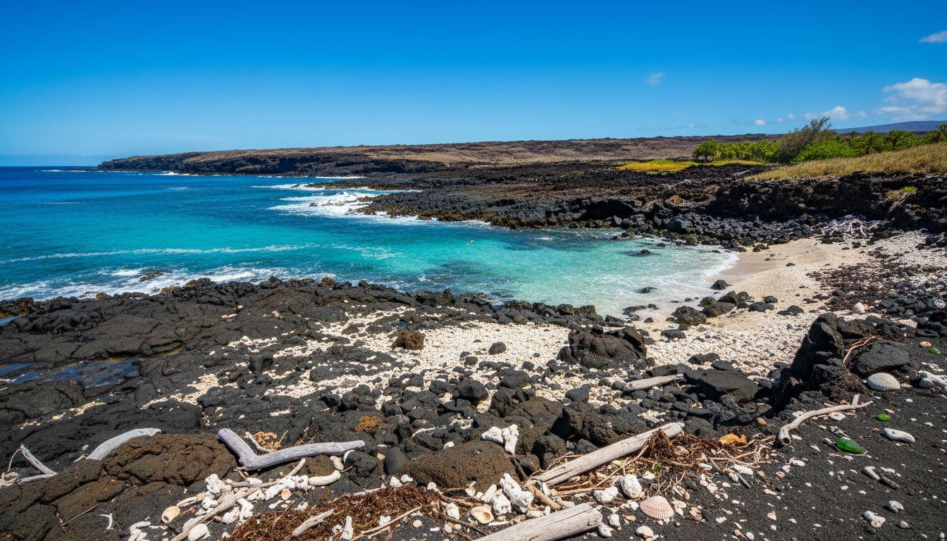
Zone 1: Pueo Bay’s black-and-white shore
The namesake bay features broken lava chunks mixed with white coral gravel. No sand exists here, just salt-and-pepper textures that crunch underfoot. Clear blue water contrasts sharply against the dark, rugged coastline where visitors arrange coral pieces into temporary messages on black rocks.
Snorkeling reveals freshwater springs on the south side creating weird temperature gradients. The brackish mix runs 5-10°F cooler than surrounding ocean water. Visibility reaches 20-50 feet during winter’s calm conditions, but strong currents demand fins and caution.
Zone 2: Golden pools of Keawaiki
A 10-minute walk inland from Pueo Bay reveals anchialine pools glowing golden from unique algae. These brackish pools connect underground to the ocean while maintaining surface freshwater layers. Hala trees mark this precious oasis amid barren volcanic destruction.
Ancient Hawaiian homestead walls surround the pools where a pre-contact community once thrived. The 1859 eruption buried their villages but somehow spared these life-giving springs. Dawn visits (sunrise 7:13am January 20, 2026) capture the golden glow at its most ethereal intensity.
Experiencing the raw power of volcanic rebirth
Zone 3 holds Keawaiki Bay’s temple ruins where an unnamed heiau once stood. The 1859 lava flow destroyed multiple ceremonial structures, leaving only scattered coral formations in tide pools as archaeological evidence. Viewing requires respectful distance of 50-100 feet from established trails.
Zone 4 challenges hikers with pure ‘a’ā terrain over the half-mile approach trail. This chunky lava averages 10-20 feet thick where the 1859 flow reached the sea. Surface temperatures run 20-40°F hotter than air temperatures during midday, making early morning hikes essential.
The ahupua’a inland connection
Zone 5 follows the Kaluoo trail segment linking coast to the Puu Anahulu ahupua’a traditional land division. This half-mile path gains 100-200 feet elevation while demonstrating how ancient Hawaiians managed resources from sea to mountain. Fish from tide pools, taro from upland plots, forest materials from higher elevations.
The trail shows ecological transition within a quarter-mile: barren lava gives way to pioneer vegetation and scattered hala trees. Big Island’s other volcanic beaches lack this intimate connection to pre-contact Hawaiian land management systems.
Zone 6: Weliweli’s unmarked wildness
The final zone extends north along unmarked coastal paths toward Weliweli Point. One mile of rugged coastline where 20-50 foot cliffs meet winter swells averaging under three feet. Experienced hikers only should attempt this section due to isolation and challenging lava navigation.
Faint cairns mark the traditional route that connected ancient Hawaiian communities along this wild Kohala coastline. Seabirds nest in cliff faces while occasional Hawaiian monk seal sightings reward patient observers maintaining the required 50-yard distance.
The earned solitude that resort beaches cannot deliver
This six-zone wilderness attracts fewer than 10 visitors daily in winter, compared to Hapuna Beach’s 500-plus crowds. The 20-minute lava approach creates a natural filter preserving authentic Hawaiian coastal experience. January 2026’s neutral La Niña conditions promise dry weather and calm seas ideal for exploration.
Unlike other empty tropical beaches, Pueo Bay’s solitude feels earned rather than accidental. The sharp ‘a’ā demands respect while golden pools reward those who make the effort. Resort guests three miles south miss this raw beauty entirely.
Your questions about Pueo Bay’s volcanic coast answered
What gear do I need for the lava trail?
Sturdy hiking boots with 5mm+ sole thickness prevent cuts from sharp ‘a’ā chunks. Water shoes work for tide pool exploration but not the approach trail. Bring two liters of water minimum, reef-safe sunscreen, and snorkel gear if desired. Water shoe rentals cost $10-15 daily in Waikoloa Village.
How does this compare to other Hawaiian beaches?
Pueo Bay offers authentic wilderness versus resort convenience. Free access contrasts with $5-30 fees at nearby state parks and resort beaches. The black lava and coral landscape provides unique photo opportunities unavailable at sand beaches. Challenging hike access filters crowds to under 10 daily visitors.
When should I visit for the best experience?
Winter months (December-February) offer calmer seas for snorkeling and cooler temperatures for lava hiking. January 2026 averages 82°F highs and 68°F lows with trade winds moderating humidity. Early morning starts (7am) avoid midday heat and capture optimal lighting for golden pool photography.
Dawn light touches the golden pools as trade winds whisper across black lava fields. Ancient Hawaiian spirits seem to linger in this place where volcanic destruction created stark, timeless beauty that no resort can replicate.