# 12 volcanic snow basins where jagged peaks dwarf winter backcountry travelers in extreme solitude
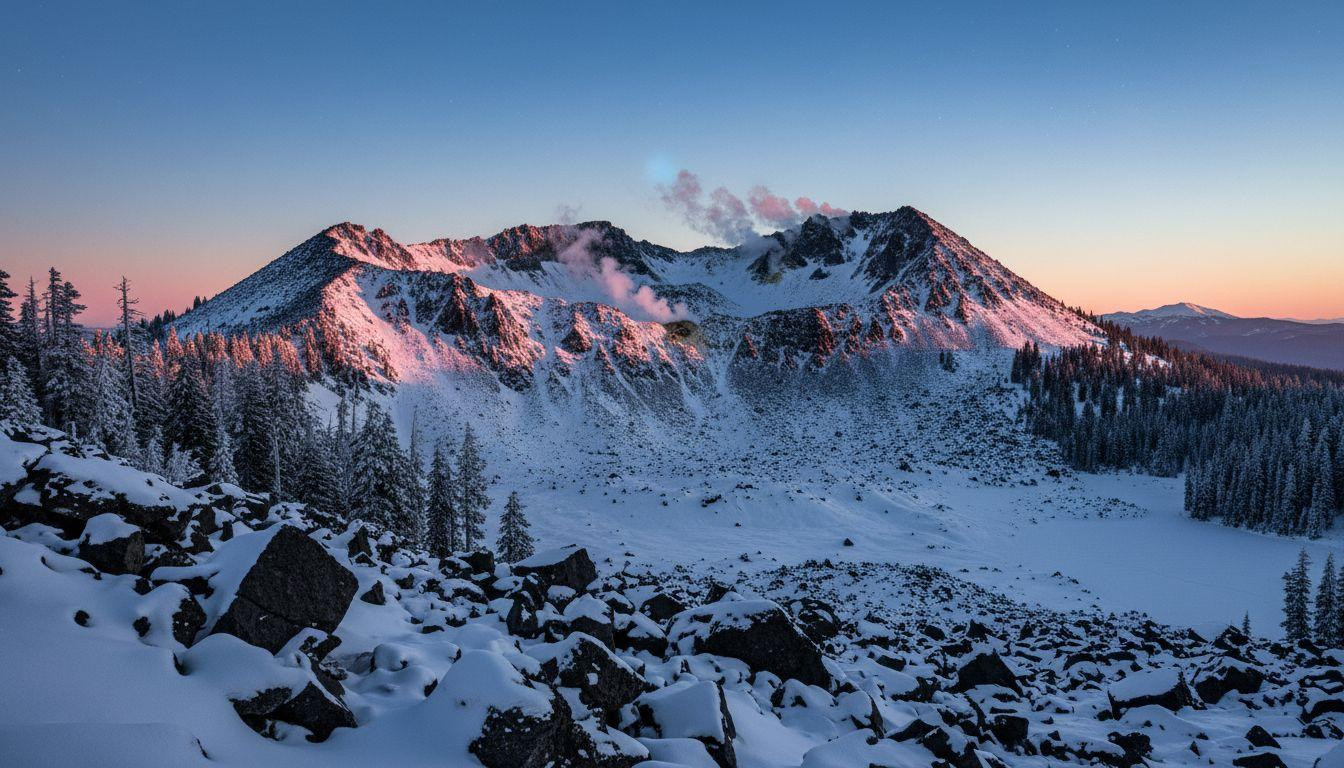
The Chaos Crags basin at dawn looks like another planet. Black dacite spires rise 1,000 feet above snowfields that glow pink in early light. Steam from distant fumaroles drifts through air so cold it stings your lungs. You stand at 8,500 feet, alone, dwarfed by volcanic domes that erupted 1,000 years ago and still feel raw.
This is winter in Lassen Volcanic National Park. No groomed trails. No ski lifts. Just 30 feet of annual snowpack covering a landscape shaped by fire and ice. The park receives under 50,000 visitors all winter, compared to half a million in summer. Most never venture beyond the visitor center parking lot.
Across the Pacific volcanic arc, a dozen basins offer this same scale and silence. Jagged peaks. Avalanche chutes cutting through lava domes. The sharp contrast of black rock against white powder. These are places where geology overwhelms, where winter access transforms summer hiking routes into technical snowshoe traverses requiring avalanche gear and off-trail navigation skills.
Chaos Crags: where volcanic domes tower over avalanche fields
The approach from Manzanita Lake trailhead covers 2.1 miles through lodgepole pine forest. Summer hikers complete this in 49 minutes. Winter snowshoers need 2-3 hours, breaking trail through powder that reaches your knees. The elevation gain feels modest at 819 feet until you emerge from the trees and see the crags.
The domes rise abruptly, their flanks too steep to hold snow. Avalanche debris fans out below, creating fields of chunky blocks you navigate around. The rockslide that dammed Manzanita Creek 300 years ago moved at 100 mph. You can still see the path it carved.
Local outfitters in Mineral rent snowshoes for $20-30 per day. The park charges $30 per vehicle for a week. Ranger-led snowshoe walks leave from Kohm Yah-mah-nee Visitor Center on weekends, free with park entry. These stick to groomed routes. The basin beyond requires your own navigation.
What the volcanic terrain feels like underfoot
Dacite and pumice create a landscape of sharp edges. Even under powder, you feel the blocky texture through snowshoe decking. The rock crunches differently than granite, more brittle. In places where wind has scoured the snow away, obsidian gleams black against white drifts.
The scale disorients. The crags appear closer than they are. What looks like a 20-minute walk takes an hour. The domes dwarf everything around them, creating optical tricks in flat winter light. During whiteouts, the landscape loses all reference points.
Why this basin stays empty all winter
Highway 89 closes to vehicles from the first major snow until late May. The park plows only to Manzanita Lake and the southwest visitor center. Everything between requires skis or snowshoes. Cell service disappears beyond the trailhead. Rescue times run 4-12 hours if weather allows helicopter access.
The terrain demands avalanche training. AIARE Level 1 certification is recommended. Beacon, probe, and shovel are required. Local gear shops in Redding rent avalanche kits for $30-50 per day. The learning curve keeps crowds away. So does the cold. Dawn temperatures at 8,500 feet in February average -5°F.
11 more volcanic basins where winter transforms the landscape
Mount Baker’s Coleman Glacier basin sits at 7,000-10,000 feet in Washington’s North Cascades. The approach from Heliotrope Ridge trailhead covers 5-7 miles through old-growth forest. Snowpack reaches 10-15 feet by February. The glacier calves occasionally, sending ice blocks tumbling down slopes. This is training terrain for Rainier climbers. Winter sees virtually no visitors.
Mount Shasta’s Avalanche Gulch rises from 9,000 to 11,000 feet in northern California. The route from Bunny Flat requires no permit but demands crampons above 10,000 feet. Snowpack averages 8-12 feet. The 1250 CE eruption left mafic shields visible as dark bands in the snow. Medicine Lake Volcano forms a halo 30 miles east. Winter access is technical and lonely.
Oregon’s volcanic trio and Hood’s active fumaroles
Three Sisters Wilderness protects triple stratovolcanoes between 7,000-10,000 feet. The Collier Cone basin requires a 6-8 mile snowshoe from Obsidian trailhead. Icefields between North and Middle Sister create crevasse hazards. Snowpack runs 8-12 feet. Wilderness permits are required year-round. Winter visitors number in the dozens.
Mount Hood’s White River basin offers the rare combination of active fumaroles and deep snow. The approach from Timberline Lodge covers 3-5 miles. Sulfur steam rises through snowfields, creating surreal contrasts. The smell intensifies in cold air, drifting 500 meters downwind. Timberline provides gear rentals and guided trips. Even with infrastructure nearby, the basin stays quiet.
Rainier’s Paradise and Adams’ south climb
Paradise snowfield at Mount Rainier receives 10-15 feet of snow by February. The 2-4 mile routes from Paradise visitor center attract more winter traffic than other basins, but numbers stay moderate. National Park Service requires permits for overnight trips. Guided snowshoe walks cost $45-65. The scale still overwhelms. Rainier’s ice mass is the largest in the lower 48 states.
Mount Adams’ south climb basin starts at Cold Springs trailhead in Gifford Pinchot National Forest. The 5-mile approach gains 3,000 feet through pumice fields buried under 8-12 feet of snow. Lewis and Clark sighted this peak from the Columbia River. Bird rookeries dot the lower slopes. Winter sees perhaps 50 visitors total.
The smaller volcanoes tourists skip
Mount McLoughlin rises to 9,500 feet in southern Oregon’s Sky Lakes Wilderness. The symmetric cone holds 6-10 feet of snow through March. The 4-mile approach requires no permit. Pumice fields create distinctive orange-brown layers in avalanche debris. Virtually empty all winter.
Crater Lake’s rim basins sit at 7,000-8,000 feet around Mount Mazama’s caldera. The 3-6 mile routes from Rim Village (when plowed) offer views of the deepest lake in the United States. Snowpack averages 8-12 feet. Rim spires create dramatic foregrounds for photography. National Park Service requires permits for backcountry travel.
Newberry Volcano’s Paulina Peak basin reaches 7,500 feet in central Oregon. The shield volcano’s 690 CE eruption left obsidian flows visible under snow. The 4-mile approach from Paulina trailhead requires no permit. Hot springs steam at the base. Winter visitors are rare enough that tracks from previous days remain visible.
Medicine Lake Volcano forms a shield complex east of Mount Shasta. Glass Mountain’s flows create black-and-white striped slopes under 6-10 feet of snow. The 5-7 mile approach through Modoc National Forest sees almost no winter use. This is Shasta’s volcanic halo, geologically linked but overlooked.
Mount Mazama’s caldera fragments scatter around Crater Lake. These remnant basins hold 8-12 feet of snow and require 4-6 miles of snowshoe access from alternate rim points. Geothermal hints appear as steam vents in pumice fields. National Park Service manages access. Winter solitude is profound.
What it feels like to be dwarfed by volcanic scale
The silence in these basins is absolute. No wind. No birds. Just the crunch of snowshoes on powder and your own breathing. The volcanic peaks rise so abruptly they seem to lean over you. Scale becomes impossible to judge. A dome that looks 500 feet tall is actually 2,000.
The black-and-white contrast creates stark beauty. No trees at elevation. No color except occasional sulfur yellow around fumaroles. The landscape feels lunar. Ancient and indifferent. You navigate by compass and altimeter because landmarks disappear in flat light.
Avalanche rumble sounds like distant thunder. The vibration travels through snowpack before you hear it. The sound measures 60-80 decibels from a kilometer away. You learn to read slopes, to avoid convex rolls and loaded chutes. The terrain demands constant attention. This is why crowds stay away. This is why those who come keep returning.
Your questions about volcanic snow basins answered
When is the best time to visit these basins?
February through March offers the most stable snowpack. Earlier in winter, storms arrive every 3-5 days. Later, spring melt creates avalanche hazards. February sees about 40% clear days. Temperatures at 8,000 feet range from -5°F at dawn to 15°F by midday. Most basins require 2-3 days for safe access and return.
What gear and training do you actually need?
AIARE Level 1 avalanche certification is strongly recommended. Required gear includes beacon, probe, shovel, snowshoes or skis, and navigation tools. Cell service is nonexistent. Satellite communicators provide emergency contact. Local outfitters in gateway towns like Redding, Bend, and Packwood rent complete kits for $50-80 per day. Winter camping requires four-season tents rated to -20°F.
How do these compare to popular ski resorts for cost and crowds?
Lift tickets at major resorts run $200-300 per day. These volcanic basins charge $30 for week-long park entry or require no fees at all. Resorts see 5,000-10,000 visitors daily in peak season. These basins see 10-50 visitors per month in winter. The tradeoff is infrastructure. No grooming. No patrol. No cell service. Just volcanic geology and profound silence.
The steam from Chaos Crags fumaroles rises straight up in still air. The plumes reach 500 meters before dispersing. Against the black dacite and white snow, they look like pillars holding up the sky. You stand in the basin, small and quiet, watching light change on ancient rock.