Wind ruins beach vacations. You book the turquoise lagoon fantasy, arrive to whitecaps and sand in your face. But barrier reefs and atoll geography create pockets where water stays glass-calm even when open ocean churns 200 yards away. These 10 islands hide natural wind protection in their bones.
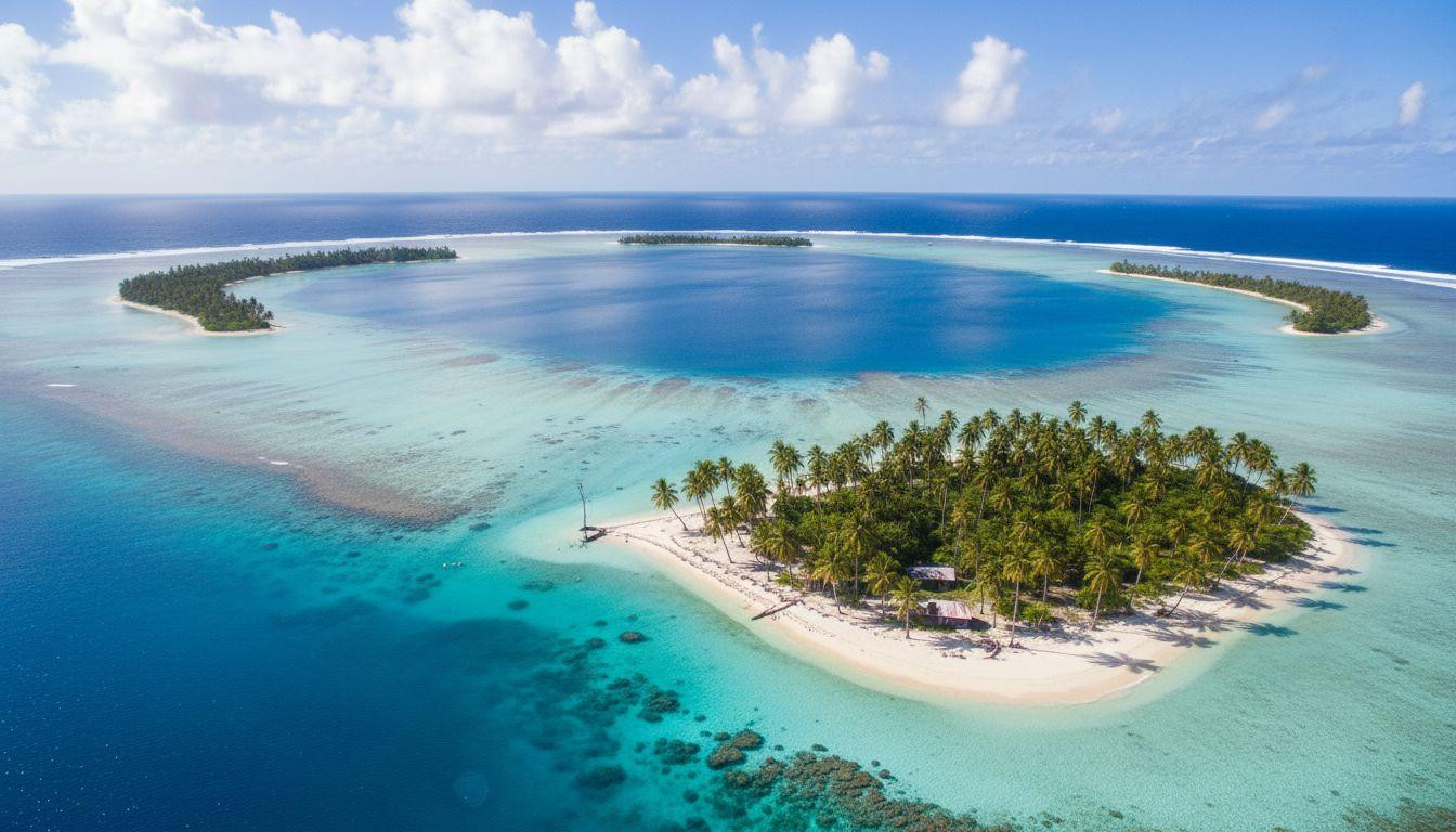
Aitutaki lagoon runs 15 miles without a ripple
The Cook Islands atoll sits at 18°50’S 159°46’W with a barrier reef circling 500 yards offshore. That reef absorbs South Pacific trade winds blowing 15-20 knots November through April while inner lagoon water stays mirror-flat. Outer reef waves hit 3-6 feet. Inside the lagoon: 6 inches.
The atoll stretches 7.5 miles across with 15 small islands called motus scattered around the rim. Lagoon depth runs 15-50 feet with visibility reaching 100 feet on calm mornings. Water temperature holds steady at 79-84°F year-round. The geography creates a natural swimming pool where wind drops 60% from reef edge to shore.
What the reef does
Barrier reefs rise 3-6 feet above average tide, breaking wave energy before it reaches the lagoon. Aitutaki’s reef sits 1,800 feet offshore at its closest point. Trade winds hit the reef at 18 knots. Inside the lagoon: 6 knots. Satellite data from 2025 shows the reef absorbs 70% of wind speed through friction and wave break.
Swimming conditions
One Foot Island sits on the southern edge at 18°48’S 159°47’W. Coral gardens start in 10 feet of water with 50 fish species and green sea turtles. Currents run under 0.5 knots. Beginners swim here safely. Mornings between 7-9am deliver the flattest water when offshore winds haven’t built yet.
Moorea hides behind volcanic cliffs and double reefs
French Polynesia’s second island sits 10 miles from Tahiti at 17°32’S 149°50’W. Two barrier reefs circle the island 1,000-2,600 feet offshore. The inner reef sits 1,000 feet out. The outer reef adds another 1,600 feet of protection. Between them: a channel that absorbs wind and wave energy before either reaches the lagoon.
Volcanic peaks rise 3,960 feet on the island’s north side. Those mountains create a wind shadow effect. Trade winds blow east at 20 knots May through October. The peaks deflect wind up and over the lagoon. At beach level: 6 knots. Water temperature runs 81°F in summer, 79°F in winter.
The double reef system
Outer reef breaks waves at 5 feet. Inner reef catches what’s left. By the time water reaches Temae Beach on the northeast coast, waves measure 4 inches. The lagoon between reefs runs 15-40 feet deep with visibility hitting 150 feet. Healthy coral coverage sits at 65% as of 2025 surveys.
Where to swim
Temae Beach at 17°30’S 149°48’W offers the calmest water. The beach faces northeast into the wind shadow. Paddleboard rentals cost $25 per hour. Snorkel gear runs $15. Manta rays visit cleaning stations 100 yards offshore. Currents stay under 0.3 knots. Even non-swimmers wade out 50 yards in waist-deep water.
Fakarava atoll circles 37 miles of protected lagoon
The Tuamotu Islands atoll at 16°04’S 145°36’W forms a nearly perfect circle 37 miles across. The barrier reef completely encircles the lagoon except for two passes. Garuae Pass on the north measures 5,250 feet wide. Tumakohua Pass on the south runs 650 feet. Between those gaps: unbroken reef absorbing trade winds that blow southeast at 18 knots.
The lagoon holds 60 square miles of water running 65-165 feet deep. Visibility reaches 200 feet. The reef rises 3 feet above tide. Wind hits the outer reef at 18 knots and drops to 4 knots inside the lagoon. That’s an 80% reduction. UNESCO designated Fakarava a Biosphere Reserve in 2006 for coral health that scores 85% coverage.
Why the circle matters
Circular atolls create uniform wind protection. Linear barrier reefs leave gaps where wind funnels through. Fakarava’s shape blocks wind from every direction. The only rough water sits near the passes where tidal currents run 0.5-1 knot. Everywhere else: flat calm. Mornings deliver mirror conditions before afternoon thermal winds build.
Swimming with sharks
Garuae Pass at 16°05’S 145°35’W hosts 700 gray reef sharks during July spawning season. They gather in the pass current but the lagoon behind stays calm. Snorkelers swim the pass edges in 15 feet of water. Dive operators charge $150 for guided trips. The lagoon itself offers beginner-friendly swimming with 100 fish species and zero current.
Roatan’s west bay sits behind the Mesoamerican reef
Honduras owns this Caribbean island at 16°06’N 86°26’W. The Mesoamerican Barrier Reef runs 100-1,000 feet offshore along the west coast. That reef system stretches 625 miles from Mexico to Honduras as the world’s second-largest barrier reef. At Roatan it rises 3-10 feet above water, breaking Caribbean trade winds that blow northeast at 15 knots.
West Bay beach faces west into the reef’s protection. Wind speed drops from 15 knots at the reef to 5 knots at the beach. Water depth runs 15-65 feet with visibility at 80 feet. Temperature holds 81-84°F year-round. The bay measures 1.5 miles long and 0.3 miles wide. Recent visitor surveys from 2025 report calm water 340 days per year.
Reef mechanics
The Mesoamerican reef sits 300 feet offshore at West Bay. Coral formations rise from 65-foot depths to 3 feet below surface. Wave energy breaks on shallow coral heads. By the time waves reach the beach they measure 3 inches. The reef also blocks northeast trade winds through friction. Air moving over rough coral loses speed.
What you’ll see
Eagle rays cruise the reef edge. Sea turtles feed in turtle grass beds 50 yards offshore. Snorkel gear rents for $25 daily. Guided reef tours cost $80. The bay stays calm enough for beginners and children. Currents run 0.17 knots according to 2025 measurements. That’s barely noticeable while swimming.
Your questions about wind-protected lagoons answered
When does wind protection matter most
Trade wind seasons vary by region. South Pacific trades blow May-October. Caribbean trades run November-April. Those months bring 15-25 knot sustained winds that create 3-6 foot waves on exposed beaches. Lagoons behind barrier reefs stay calm during peak wind months. Visit during trade wind season to see the protection difference. Exposed beaches will be rough while lagoons stay flat.
How much does reef distance affect calm water
Reefs within 300 yards of shore provide maximum wind protection. Reefs 1,000+ yards out still break waves but wind reaches the beach. Aitutaki’s reef sits 500 yards out and blocks 70% of wind. Moorea’s double reef system at 1,000 and 2,600 feet blocks 65%. Fakarava’s continuous circular reef delivers 80% protection. The closer and more complete the reef, the calmer the lagoon.
Do these lagoons cost more than open beaches
Aitutaki rooms start at $250 nightly. Moorea runs $300-600. Fakarava costs $280-500. Roatan offers $250-450. Compare that to Bora Bora at $500-1,200 or Maldives at $400-2,000. Protected lagoons cost 30-50% less than luxury resort islands. Flights add expense. Aitutaki requires connections through Rarotonga. Fakarava connects through Tahiti. Roatan offers direct flights from Miami for $300 round-trip.
Morning light turns Aitutaki’s lagoon into liquid turquoise. The water sits so still you see clouds reflected perfectly. Wind bends palms at the reef edge 500 yards out. Inside the lagoon: silence. That’s what geography does when it blocks wind.